You are here: Home > Network List > TA - USArray Transportable Network (new EarthScope stations) Stations List
> Station K02D Willamette Meridian, OR, USA > Earthquake Result Viewer
K02D Willamette Meridian, OR, USA - Earthquake Result Viewer
| Earthquake location: |
Vanuatu Islands |
| Earthquake latitude/longitude: |
-17.8/167.1 |
| Earthquake time(UTC): |
2012/02/02 (033) 13:34:40 GMT |
| Earthquake Depth: |
23 km |
| Earthquake Magnitude: |
6.5 MB, 6.9 MS, 7.1 MW, 7.1 MW |
| Earthquake Catalog/Contributor: |
WHDF/NEIC |
|
| Network: |
TA USArray Transportable Network (new EarthScope stations) |
| Station: |
K02D Willamette Meridian, OR, USA |
| Lat/Lon: |
42.70 N/123.67 W |
| Elevation: |
989 m |
|
| Distance: |
87.5 deg |
| Az: |
43.618 deg |
| Baz: |
243.045 deg |
| Ray Param: |
0.043266363 |
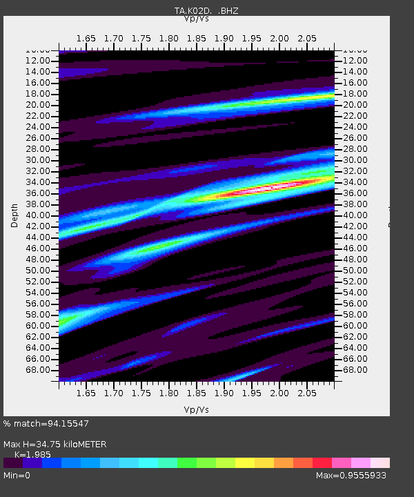
| Estimated Moho Depth: |
34.75 km |
| Estimated Crust Vp/Vs: |
1.99 |
| Assumed Crust Vp: |
6.522 km/s |
| Estimated Crust Vs: |
3.285 km/s |
| Estimated Crust Poisson's Ratio: |
0.33 |
|
| Radial Match: |
94.15547 % |
| Radial Bump: |
392 |
| Transverse Match: |
86.48201 % |
| Transverse Bump: |
400 |
| SOD ConfigId: |
436445 |
| Insert Time: |
2012-04-11 06:31:38.940 +0000 |
| GWidth: |
2.5 |
| Max Bumps: |
400 |
| Tol: |
0.001 |
|
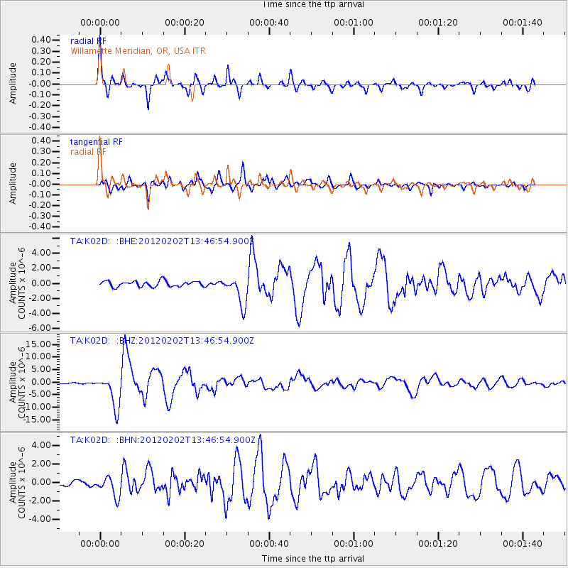
Signal To Noise
| Channel | StoN | STA | LTA |
| TA:K02D: :BHZ:20120202T13:46:54.900Z | 16.969471 | 6.824723E-6 | 4.0217654E-7 |
| TA:K02D: :BHN:20120202T13:46:54.900Z | 4.600631 | 1.1023957E-6 | 2.3961837E-7 |
| TA:K02D: :BHE:20120202T13:46:54.900Z | 5.3943143 | 2.00187E-6 | 3.7110743E-7 |
| Arrivals |
| Ps | 5.4 SECOND |
| PpPs | 16 SECOND |
| PsPs/PpSs | 21 SECOND |


