You are here: Home > Network List > X812 - Deep Structure of Three Continental Sutures in Eastern North America Stations List
> Station QM80 Route du Nord, Quebec, Canada > Earthquake Result Viewer
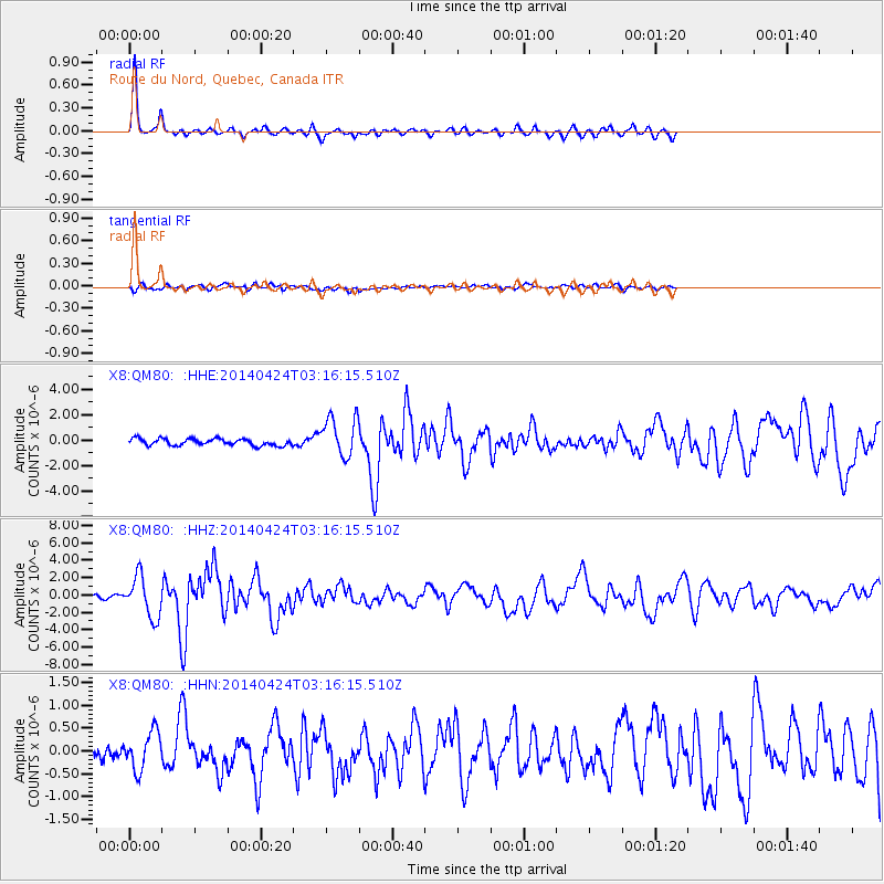
QM80 Route du Nord, Quebec, Canada - Earthquake Result Viewer

| Earthquake location: |
Vancouver Island, Canada Region |
| Earthquake latitude/longitude: |
49.8/-127.4 |
| Earthquake time(UTC): |
2014/04/24 (114) 03:10:13 GMT |
| Earthquake Depth: |
11 km |
| Earthquake Magnitude: |
6.7 MWP, 6.7 MI |
| Earthquake Catalog/Contributor: |
NEIC PDE/NEIC COMCAT |
|
| Network: |
X8 Deep Structure of Three Continental Sutures in Eastern North America |
| Station: |
QM80 Route du Nord, Quebec, Canada |
| Lat/Lon: |
50.96 N/75.23 W |
| Elevation: |
371 m |
|
| Distance: |
32.7 deg |
| Az: |
67.586 deg |
| Baz: |
288.846 deg |
| Ray Param: |
0.078530714 |
| Estimated Moho Depth: |
41.5 km |
| Estimated Crust Vp/Vs: |
1.60 |
| Assumed Crust Vp: |
6.61 km/s |
| Estimated Crust Vs: |
4.125 km/s |
| Estimated Crust Poisson's Ratio: |
0.18 |
|
| Radial Match: |
85.72849 % |
| Radial Bump: |
273 |
| Transverse Match: |
51.255478 % |
| Transverse Bump: |
400 |
| SOD ConfigId: |
3390531 |
| Insert Time: |
2019-04-11 14:32:53.882 +0000 |
| GWidth: |
2.5 |
| Max Bumps: |
400 |
| Tol: |
0.001 |
|
Signal To Noise
| Channel | StoN | STA | LTA |
| X8:QM80: :HHZ:20140424T03:16:15.510Z | 9.757889 | 2.3201546E-6 | 2.377722E-7 |
| X8:QM80: :HHN:20140424T03:16:15.510Z | 2.2783868 | 4.128643E-7 | 1.8120903E-7 |
| X8:QM80: :HHE:20140424T03:16:15.510Z | 4.9827504 | 1.323442E-6 | 2.656047E-7 |
| Arrivals |
| Ps | 4.2 SECOND |
| PpPs | 15 SECOND |
| PsPs/PpSs | 19 SECOND |


