You are here: Home > Network List > TA - USArray Transportable Network (new EarthScope stations) Stations List
> Station I02D Swisshome, OR, USA > Earthquake Result Viewer
I02D Swisshome, OR, USA - Earthquake Result Viewer
| Earthquake location: |
Vanuatu Islands |
| Earthquake latitude/longitude: |
-17.8/167.1 |
| Earthquake time(UTC): |
2012/02/02 (033) 13:34:40 GMT |
| Earthquake Depth: |
23 km |
| Earthquake Magnitude: |
6.5 MB, 6.9 MS, 7.1 MW, 7.1 MW |
| Earthquake Catalog/Contributor: |
WHDF/NEIC |
|
| Network: |
TA USArray Transportable Network (new EarthScope stations) |
| Station: |
I02D Swisshome, OR, USA |
| Lat/Lon: |
44.11 N/123.85 W |
| Elevation: |
109 m |
|
| Distance: |
88.0 deg |
| Az: |
42.302 deg |
| Baz: |
242.869 deg |
| Ray Param: |
0.04287859 |
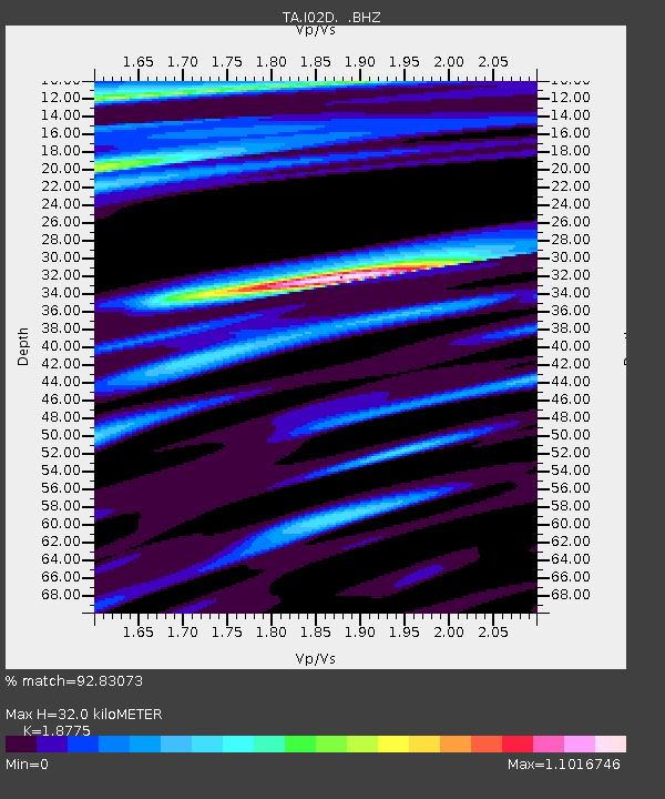
| Estimated Moho Depth: |
32.0 km |
| Estimated Crust Vp/Vs: |
1.88 |
| Assumed Crust Vp: |
6.566 km/s |
| Estimated Crust Vs: |
3.497 km/s |
| Estimated Crust Poisson's Ratio: |
0.30 |
|
| Radial Match: |
92.83073 % |
| Radial Bump: |
400 |
| Transverse Match: |
82.6615 % |
| Transverse Bump: |
400 |
| SOD ConfigId: |
436445 |
| Insert Time: |
2012-04-11 06:31:55.265 +0000 |
| GWidth: |
2.5 |
| Max Bumps: |
400 |
| Tol: |
0.001 |
|
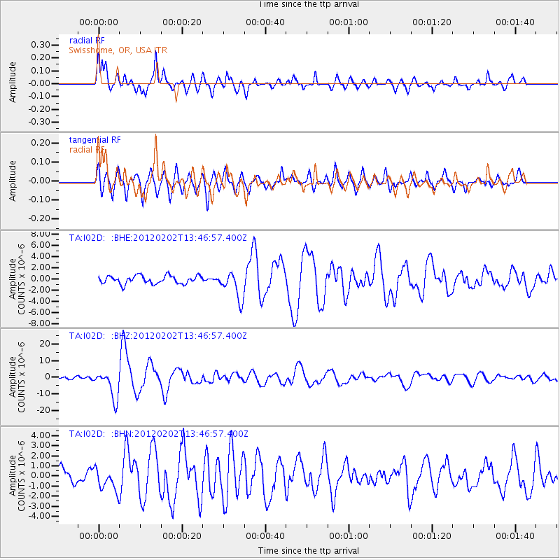
Signal To Noise
| Channel | StoN | STA | LTA |
| TA:I02D: :BHZ:20120202T13:46:57.400Z | 13.265426 | 8.781064E-6 | 6.619511E-7 |
| TA:I02D: :BHN:20120202T13:46:57.400Z | 1.8290571 | 1.1451048E-6 | 6.2606284E-7 |
| TA:I02D: :BHE:20120202T13:46:57.400Z | 3.5786889 | 2.545001E-6 | 7.111546E-7 |
| Arrivals |
| Ps | 4.4 SECOND |
| PpPs | 14 SECOND |
| PsPs/PpSs | 18 SECOND |


