You are here: Home > Network List > UW - Pacific Northwest Regional Seismic Network Stations List
> Station TAKO Tahkenitch, OR CREST BB SMO > Earthquake Result Viewer
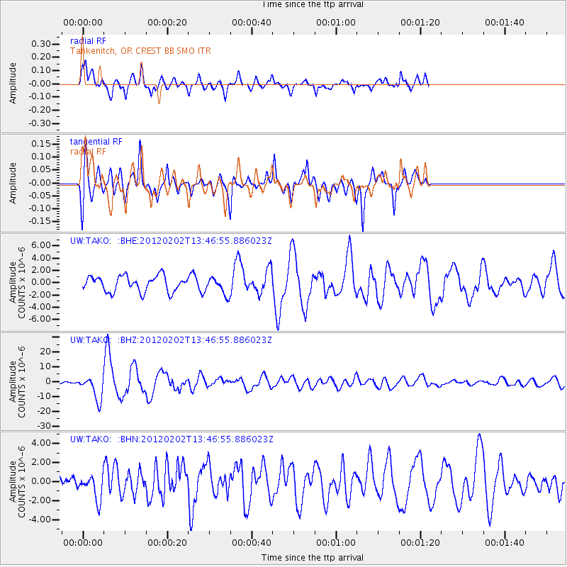
TAKO Tahkenitch, OR CREST BB SMO - Earthquake Result Viewer
*The percent match for this event was below the threshold and hence no stack was calculated.
| Earthquake location: |
Vanuatu Islands |
| Earthquake latitude/longitude: |
-17.8/167.1 |
| Earthquake time(UTC): |
2012/02/02 (033) 13:34:40 GMT |
| Earthquake Depth: |
23 km |
| Earthquake Magnitude: |
6.5 MB, 6.9 MS, 7.1 MW, 7.1 MW |
| Earthquake Catalog/Contributor: |
WHDF/NEIC |
|
| Network: |
UW Pacific Northwest Regional Seismic Network |
| Station: |
TAKO Tahkenitch, OR CREST BB SMO |
| Lat/Lon: |
43.74 N/124.08 W |
| Elevation: |
46 m |
|
| Distance: |
87.7 deg |
| Az: |
42.546 deg |
| Baz: |
242.715 deg |
| Ray Param: |
$rayparam |
*The percent match for this event was below the threshold and hence was not used in the summary stack. |
|
| Radial Match: |
75.3071 % |
| Radial Bump: |
364 |
| Transverse Match: |
85.201614 % |
| Transverse Bump: |
400 |
| SOD ConfigId: |
436445 |
| Insert Time: |
2012-04-11 06:35:00.918 +0000 |
| GWidth: |
2.5 |
| Max Bumps: |
400 |
| Tol: |
0.001 |
|
Signal To Noise
| Channel | StoN | STA | LTA |
| UW:TAKO: :BHZ:20120202T13:46:55.886023Z | 15.597281 | 8.294812E-6 | 5.3181134E-7 |
| UW:TAKO: :BHN:20120202T13:46:55.886023Z | 1.9248912 | 1.3471794E-6 | 6.99873E-7 |
| UW:TAKO: :BHE:20120202T13:46:55.886023Z | 1.1112854 | 1.3986518E-6 | 1.2585891E-6 |
| Arrivals |
| Ps | |
| PpPs | |
| PsPs/PpSs | |


