You are here: Home > Network List > TA - USArray Transportable Network (new EarthScope stations) Stations List
> Station M04C Macdoel, CA, USA > Earthquake Result Viewer
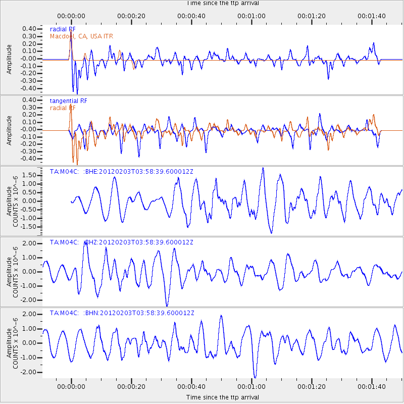
M04C Macdoel, CA, USA - Earthquake Result Viewer
*The percent match for this event was below the threshold and hence no stack was calculated.
| Earthquake location: |
Vanuatu Islands |
| Earthquake latitude/longitude: |
-17.4/167.3 |
| Earthquake time(UTC): |
2012/02/03 (034) 03:46:21 GMT |
| Earthquake Depth: |
8.0 km |
| Earthquake Magnitude: |
5.9 MB, 5.8 MS, 6.1 MW, 6.1 MW |
| Earthquake Catalog/Contributor: |
WHDF/NEIC |
|
| Network: |
TA USArray Transportable Network (new EarthScope stations) |
| Station: |
M04C Macdoel, CA, USA |
| Lat/Lon: |
41.78 N/121.84 W |
| Elevation: |
1391 m |
|
| Distance: |
87.9 deg |
| Az: |
45.002 deg |
| Baz: |
244.539 deg |
| Ray Param: |
$rayparam |
*The percent match for this event was below the threshold and hence was not used in the summary stack. |
|
| Radial Match: |
72.73416 % |
| Radial Bump: |
400 |
| Transverse Match: |
54.542336 % |
| Transverse Bump: |
339 |
| SOD ConfigId: |
436445 |
| Insert Time: |
2012-04-11 07:01:38.415 +0000 |
| GWidth: |
2.5 |
| Max Bumps: |
400 |
| Tol: |
0.001 |
|
Signal To Noise
| Channel | StoN | STA | LTA |
| TA:M04C: :BHZ:20120203T03:58:39.600012Z | 1.5428187 | 1.0351106E-6 | 6.709217E-7 |
| TA:M04C: :BHN:20120203T03:58:39.600012Z | 1.3069874 | 7.935537E-7 | 6.0716246E-7 |
| TA:M04C: :BHE:20120203T03:58:39.600012Z | 0.89127743 | 5.3992267E-7 | 6.0578515E-7 |
| Arrivals |
| Ps | |
| PpPs | |
| PsPs/PpSs | |


