You are here: Home > Network List > CI - Caltech Regional Seismic Network Stations List
> Station LGU LGU, Camarillo, CA, USA > Earthquake Result Viewer
LGU LGU, Camarillo, CA, USA - Earthquake Result Viewer
| Earthquake location: |
Near S. Coast Of Honshu, Japan |
| Earthquake latitude/longitude: |
33.2/137.9 |
| Earthquake time(UTC): |
2009/08/09 (221) 10:55:55 GMT |
| Earthquake Depth: |
297 km |
| Earthquake Magnitude: |
6.5 MB, 7.1 MW, 7.1 MW |
| Earthquake Catalog/Contributor: |
WHDF/NEIC |
|
| Network: |
CI Caltech Regional Seismic Network |
| Station: |
LGU LGU, Camarillo, CA, USA |
| Lat/Lon: |
34.11 N/119.07 W |
| Elevation: |
416 m |
|
| Distance: |
81.5 deg |
| Az: |
54.827 deg |
| Baz: |
304.278 deg |
| Ray Param: |
0.046753533 |
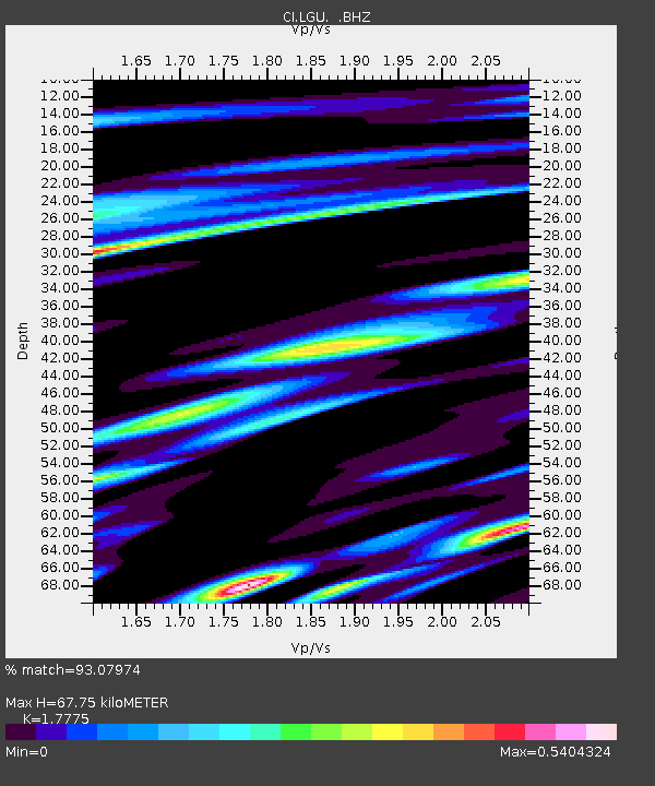
| Estimated Moho Depth: |
67.75 km |
| Estimated Crust Vp/Vs: |
1.78 |
| Assumed Crust Vp: |
6.1 km/s |
| Estimated Crust Vs: |
3.432 km/s |
| Estimated Crust Poisson's Ratio: |
0.27 |
|
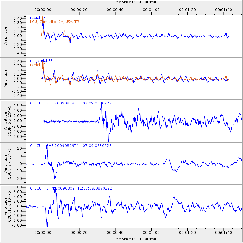
| Radial Match: |
93.07974 % |
| Radial Bump: |
400 |
| Transverse Match: |
84.05621 % |
| Transverse Bump: |
400 |
| SOD ConfigId: |
2622 |
| Insert Time: |
2010-02-25 20:20:26.262 +0000 |
| GWidth: |
2.5 |
| Max Bumps: |
400 |
| Tol: |
0.001 |
|
Signal To Noise
| Channel | StoN | STA | LTA |
| CI:LGU: :BHZ:20090809T11:07:09.083022Z | 65.70287 | 9.516862E-6 | 1.4484695E-7 |
| CI:LGU: :BHN:20090809T11:07:09.083022Z | 19.255285 | 3.0465283E-6 | 1.5821776E-7 |
| CI:LGU: :BHE:20090809T11:07:09.083022Z | 14.170118 | 2.6721902E-6 | 1.8857924E-7 |
| Arrivals |
| Ps | 8.8 SECOND |
| PpPs | 30 SECOND |
| PsPs/PpSs | 39 SECOND |


