You are here: Home > Network List > TA - USArray Transportable Network (new EarthScope stations) Stations List
> Station J05D Fort Rock, OR, USA > Earthquake Result Viewer
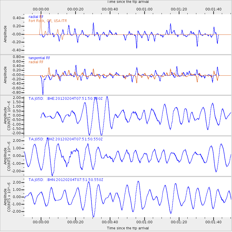
J05D Fort Rock, OR, USA - Earthquake Result Viewer
*The percent match for this event was below the threshold and hence no stack was calculated.
| Earthquake location: |
Tonga Islands |
| Earthquake latitude/longitude: |
-20.5/-174.0 |
| Earthquake time(UTC): |
2012/02/04 (035) 07:40:12 GMT |
| Earthquake Depth: |
8.0 km |
| Earthquake Magnitude: |
5.5 MB, 5.5 MS, 5.8 MW, 5.7 MW |
| Earthquake Catalog/Contributor: |
WHDF/NEIC |
|
| Network: |
TA USArray Transportable Network (new EarthScope stations) |
| Station: |
J05D Fort Rock, OR, USA |
| Lat/Lon: |
43.28 N/121.23 W |
| Elevation: |
1541 m |
|
| Distance: |
79.9 deg |
| Az: |
36.217 deg |
| Baz: |
229.315 deg |
| Ray Param: |
$rayparam |
*The percent match for this event was below the threshold and hence was not used in the summary stack. |
|
| Radial Match: |
65.07999 % |
| Radial Bump: |
400 |
| Transverse Match: |
74.93099 % |
| Transverse Bump: |
366 |
| SOD ConfigId: |
436445 |
| Insert Time: |
2012-04-11 07:52:17.608 +0000 |
| GWidth: |
2.5 |
| Max Bumps: |
400 |
| Tol: |
0.001 |
|
Signal To Noise
| Channel | StoN | STA | LTA |
| TA:J05D: :BHZ:20120204T07:51:50.550Z | 2.8370411 | 1.5285935E-6 | 5.3879853E-7 |
| TA:J05D: :BHN:20120204T07:51:50.550Z | 1.5307691 | 7.3108924E-7 | 4.775961E-7 |
| TA:J05D: :BHE:20120204T07:51:50.550Z | 3.7690773 | 1.4003845E-6 | 3.715457E-7 |
| Arrivals |
| Ps | |
| PpPs | |
| PsPs/PpSs | |


