You are here: Home > Network List > TA - USArray Transportable Network (new EarthScope stations) Stations List
> Station L37A Phoenix Point, Boone, IA, USA > Earthquake Result Viewer
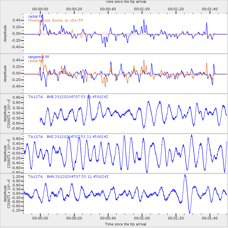
L37A Phoenix Point, Boone, IA, USA - Earthquake Result Viewer
*The percent match for this event was below the threshold and hence no stack was calculated.
| Earthquake location: |
Tonga Islands |
| Earthquake latitude/longitude: |
-20.5/-174.0 |
| Earthquake time(UTC): |
2012/02/04 (035) 07:40:12 GMT |
| Earthquake Depth: |
8.0 km |
| Earthquake Magnitude: |
5.5 MB, 5.5 MS, 5.8 MW, 5.7 MW |
| Earthquake Catalog/Contributor: |
WHDF/NEIC |
|
| Network: |
TA USArray Transportable Network (new EarthScope stations) |
| Station: |
L37A Phoenix Point, Boone, IA, USA |
| Lat/Lon: |
42.12 N/93.75 W |
| Elevation: |
312 m |
|
| Distance: |
96.6 deg |
| Az: |
47.576 deg |
| Baz: |
248.431 deg |
| Ray Param: |
$rayparam |
*The percent match for this event was below the threshold and hence was not used in the summary stack. |
|
| Radial Match: |
71.95897 % |
| Radial Bump: |
400 |
| Transverse Match: |
57.16792 % |
| Transverse Bump: |
400 |
| SOD ConfigId: |
436445 |
| Insert Time: |
2012-04-11 07:55:00.166 +0000 |
| GWidth: |
2.5 |
| Max Bumps: |
400 |
| Tol: |
0.001 |
|
Signal To Noise
| Channel | StoN | STA | LTA |
| TA:L37A: :BHZ:20120204T07:53:11.450024Z | 0.35264802 | 1.27899E-7 | 3.6268176E-7 |
| TA:L37A: :BHN:20120204T07:53:11.450024Z | 2.4109485 | 4.5006138E-7 | 1.8667399E-7 |
| TA:L37A: :BHE:20120204T07:53:11.450024Z | 1.3615814 | 3.8010245E-7 | 2.791625E-7 |
| Arrivals |
| Ps | |
| PpPs | |
| PsPs/PpSs | |


