You are here: Home > Network List > TA - USArray Transportable Network (new EarthScope stations) Stations List
> Station R41A Rosebud, MO, USA > Earthquake Result Viewer
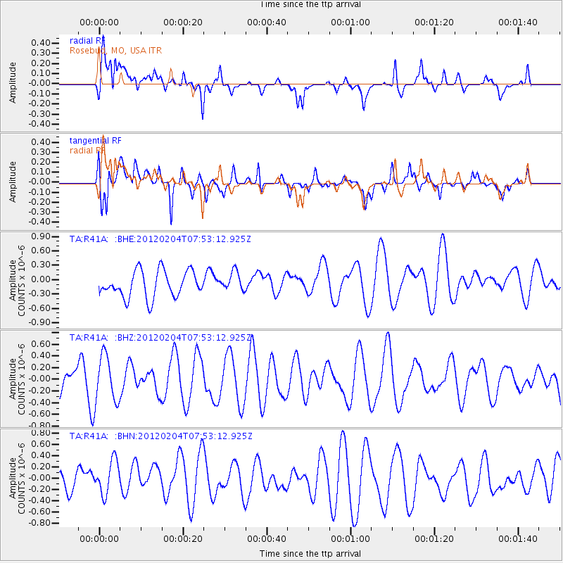
R41A Rosebud, MO, USA - Earthquake Result Viewer
*The percent match for this event was below the threshold and hence no stack was calculated.
| Earthquake location: |
Tonga Islands |
| Earthquake latitude/longitude: |
-20.5/-174.0 |
| Earthquake time(UTC): |
2012/02/04 (035) 07:40:12 GMT |
| Earthquake Depth: |
8.0 km |
| Earthquake Magnitude: |
5.5 MB, 5.5 MS, 5.8 MW, 5.7 MW |
| Earthquake Catalog/Contributor: |
WHDF/NEIC |
|
| Network: |
TA USArray Transportable Network (new EarthScope stations) |
| Station: |
R41A Rosebud, MO, USA |
| Lat/Lon: |
38.30 N/91.38 W |
| Elevation: |
257 m |
|
| Distance: |
96.9 deg |
| Az: |
51.826 deg |
| Baz: |
249.457 deg |
| Ray Param: |
$rayparam |
*The percent match for this event was below the threshold and hence was not used in the summary stack. |
|
| Radial Match: |
46.87271 % |
| Radial Bump: |
400 |
| Transverse Match: |
53.938164 % |
| Transverse Bump: |
400 |
| SOD ConfigId: |
436445 |
| Insert Time: |
2012-04-11 07:58:48.634 +0000 |
| GWidth: |
2.5 |
| Max Bumps: |
400 |
| Tol: |
0.001 |
|
Signal To Noise
| Channel | StoN | STA | LTA |
| TA:R41A: :BHZ:20120204T07:53:12.925Z | 1.2319336 | 3.8671598E-7 | 3.139098E-7 |
| TA:R41A: :BHN:20120204T07:53:12.925Z | 1.666308 | 3.0657677E-7 | 1.8398563E-7 |
| TA:R41A: :BHE:20120204T07:53:12.925Z | 0.74907905 | 2.0463438E-7 | 2.7318129E-7 |
| Arrivals |
| Ps | |
| PpPs | |
| PsPs/PpSs | |


