You are here: Home > Network List > UW - Pacific Northwest Regional Seismic Network Stations List
> Station UMAT Pilot Rock, OR, USA > Earthquake Result Viewer
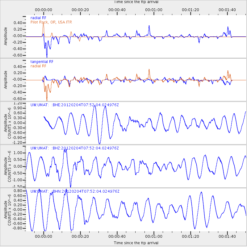
UMAT Pilot Rock, OR, USA - Earthquake Result Viewer
*The percent match for this event was below the threshold and hence no stack was calculated.
| Earthquake location: |
Tonga Islands |
| Earthquake latitude/longitude: |
-20.5/-174.0 |
| Earthquake time(UTC): |
2012/02/04 (035) 07:40:12 GMT |
| Earthquake Depth: |
8.0 km |
| Earthquake Magnitude: |
5.5 MB, 5.5 MS, 5.8 MW, 5.7 MW |
| Earthquake Catalog/Contributor: |
WHDF/NEIC |
|
| Network: |
UW Pacific Northwest Regional Seismic Network |
| Station: |
UMAT Pilot Rock, OR, USA |
| Lat/Lon: |
45.29 N/118.96 W |
| Elevation: |
1318 m |
|
| Distance: |
82.4 deg |
| Az: |
35.722 deg |
| Baz: |
230.822 deg |
| Ray Param: |
$rayparam |
*The percent match for this event was below the threshold and hence was not used in the summary stack. |
|
| Radial Match: |
71.9528 % |
| Radial Bump: |
307 |
| Transverse Match: |
55.820206 % |
| Transverse Bump: |
352 |
| SOD ConfigId: |
436445 |
| Insert Time: |
2012-04-11 08:01:11.229 +0000 |
| GWidth: |
2.5 |
| Max Bumps: |
400 |
| Tol: |
0.001 |
|
Signal To Noise
| Channel | StoN | STA | LTA |
| UW:UMAT: :BHZ:20120204T07:52:04.024976Z | 0.8604767 | 4.6900138E-7 | 5.4504835E-7 |
| UW:UMAT: :BHN:20120204T07:52:04.024976Z | 1.4018723 | 6.1565277E-7 | 4.3916467E-7 |
| UW:UMAT: :BHE:20120204T07:52:04.024976Z | 2.0642567 | 8.101288E-7 | 3.9245546E-7 |
| Arrivals |
| Ps | |
| PpPs | |
| PsPs/PpSs | |


