You are here: Home > Network List > UW - Pacific Northwest Regional Seismic Network Stations List
> Station HOOD Mt Hood Meadows, OR CREST BB SMO > Earthquake Result Viewer
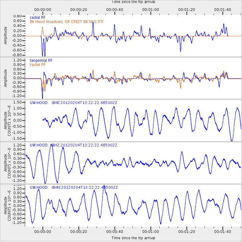
HOOD Mt Hood Meadows, OR CREST BB SMO - Earthquake Result Viewer
*The percent match for this event was below the threshold and hence no stack was calculated.
| Earthquake location: |
Samar, Philippines |
| Earthquake latitude/longitude: |
11.9/125.8 |
| Earthquake time(UTC): |
2012/02/04 (035) 13:09:23 GMT |
| Earthquake Depth: |
12 km |
| Earthquake Magnitude: |
5.6 MB, 5.4 MS, 5.6 MW, 5.8 MW |
| Earthquake Catalog/Contributor: |
WHDF/NEIC |
|
| Network: |
UW Pacific Northwest Regional Seismic Network |
| Station: |
HOOD Mt Hood Meadows, OR CREST BB SMO |
| Lat/Lon: |
45.32 N/121.65 W |
| Elevation: |
1520 m |
|
| Distance: |
96.9 deg |
| Az: |
41.007 deg |
| Baz: |
294.44 deg |
| Ray Param: |
$rayparam |
*The percent match for this event was below the threshold and hence was not used in the summary stack. |
|
| Radial Match: |
69.80759 % |
| Radial Bump: |
400 |
| Transverse Match: |
58.87696 % |
| Transverse Bump: |
400 |
| SOD ConfigId: |
436445 |
| Insert Time: |
2012-04-11 08:16:52.139 +0000 |
| GWidth: |
2.5 |
| Max Bumps: |
400 |
| Tol: |
0.001 |
|
Signal To Noise
| Channel | StoN | STA | LTA |
| UW:HOOD: :BHZ:20120204T13:22:22.485002Z | 2.811502 | 8.614407E-7 | 3.0639876E-7 |
| UW:HOOD: :BHN:20120204T13:22:22.485002Z | 0.6167541 | 4.873238E-7 | 7.9014285E-7 |
| UW:HOOD: :BHE:20120204T13:22:22.485002Z | 2.2993438 | 8.0987445E-7 | 3.522198E-7 |
| Arrivals |
| Ps | |
| PpPs | |
| PsPs/PpSs | |


