You are here: Home > Network List > CI - Caltech Regional Seismic Network Stations List
> Station MPM Manuel Prospect Mine, California, USA > Earthquake Result Viewer
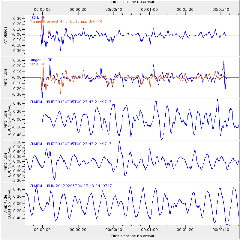
MPM Manuel Prospect Mine, California, USA - Earthquake Result Viewer
*The percent match for this event was below the threshold and hence no stack was calculated.
| Earthquake location: |
Vanuatu Islands |
| Earthquake latitude/longitude: |
-18.9/168.9 |
| Earthquake time(UTC): |
2012/02/05 (036) 00:15:38 GMT |
| Earthquake Depth: |
145 km |
| Earthquake Magnitude: |
6.1 MW, 5.4 MB, 6.1 MW |
| Earthquake Catalog/Contributor: |
WHDF/NEIC |
|
| Network: |
CI Caltech Regional Seismic Network |
| Station: |
MPM Manuel Prospect Mine, California, USA |
| Lat/Lon: |
36.06 N/117.49 W |
| Elevation: |
185 m |
|
| Distance: |
88.4 deg |
| Az: |
51.042 deg |
| Baz: |
245.311 deg |
| Ray Param: |
$rayparam |
*The percent match for this event was below the threshold and hence was not used in the summary stack. |
|
| Radial Match: |
47.244328 % |
| Radial Bump: |
400 |
| Transverse Match: |
60.199425 % |
| Transverse Bump: |
400 |
| SOD ConfigId: |
436445 |
| Insert Time: |
2012-04-21 04:48:21.382 +0000 |
| GWidth: |
2.5 |
| Max Bumps: |
400 |
| Tol: |
0.001 |
|
Signal To Noise
| Channel | StoN | STA | LTA |
| CI:MPM: :BHZ:20120205T00:27:43.244971Z | 2.8073938 | 4.6363996E-7 | 1.651496E-7 |
| CI:MPM: :BHN:20120205T00:27:43.244971Z | 0.9426193 | 1.569055E-7 | 1.6645691E-7 |
| CI:MPM: :BHE:20120205T00:27:43.244971Z | 1.4496387 | 1.8992316E-7 | 1.3101413E-7 |
| Arrivals |
| Ps | |
| PpPs | |
| PsPs/PpSs | |


