You are here: Home > Network List > TA - USArray Transportable Network (new EarthScope stations) Stations List
> Station L04D Klamath Falls, OR, USA > Earthquake Result Viewer
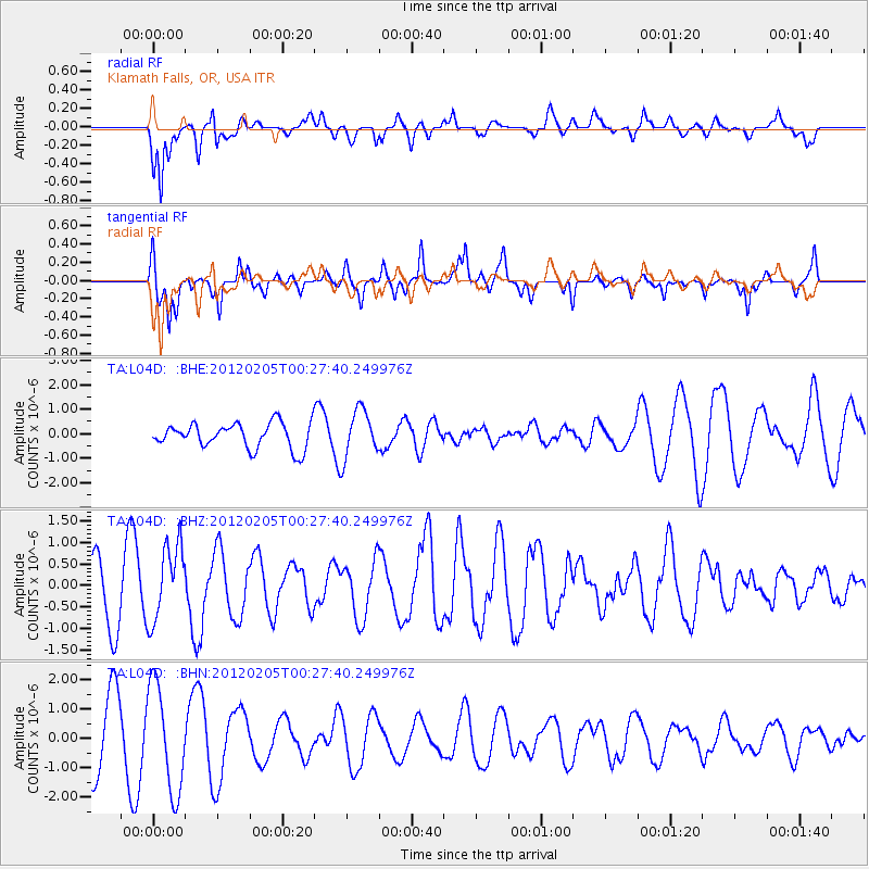
L04D Klamath Falls, OR, USA - Earthquake Result Viewer
*The percent match for this event was below the threshold and hence no stack was calculated.
| Earthquake location: |
Vanuatu Islands |
| Earthquake latitude/longitude: |
-18.9/168.9 |
| Earthquake time(UTC): |
2012/02/05 (036) 00:15:38 GMT |
| Earthquake Depth: |
145 km |
| Earthquake Magnitude: |
6.1 MW, 5.4 MB, 6.1 MW |
| Earthquake Catalog/Contributor: |
WHDF/NEIC |
|
| Network: |
TA USArray Transportable Network (new EarthScope stations) |
| Station: |
L04D Klamath Falls, OR, USA |
| Lat/Lon: |
42.22 N/122.30 W |
| Elevation: |
1437 m |
|
| Distance: |
87.8 deg |
| Az: |
43.867 deg |
| Baz: |
242.037 deg |
| Ray Param: |
$rayparam |
*The percent match for this event was below the threshold and hence was not used in the summary stack. |
|
| Radial Match: |
78.50329 % |
| Radial Bump: |
400 |
| Transverse Match: |
73.29412 % |
| Transverse Bump: |
313 |
| SOD ConfigId: |
436445 |
| Insert Time: |
2012-04-21 04:52:17.967 +0000 |
| GWidth: |
2.5 |
| Max Bumps: |
400 |
| Tol: |
0.001 |
|
Signal To Noise
| Channel | StoN | STA | LTA |
| TA:L04D: :BHZ:20120205T00:27:40.249976Z | 1.5345803 | 8.9138837E-7 | 5.808679E-7 |
| TA:L04D: :BHN:20120205T00:27:40.249976Z | 1.6283586 | 1.8070998E-6 | 1.1097677E-6 |
| TA:L04D: :BHE:20120205T00:27:40.249976Z | 1.8945458 | 9.714832E-7 | 5.1277897E-7 |
| Arrivals |
| Ps | |
| PpPs | |
| PsPs/PpSs | |


