You are here: Home > Network List > TA - USArray Transportable Network (new EarthScope stations) Stations List
> Station O03D Paynes Creek, CA, USA > Earthquake Result Viewer
O03D Paynes Creek, CA, USA - Earthquake Result Viewer
*The percent match for this event was below the threshold and hence no stack was calculated.
| Earthquake location: |
Vanuatu Islands |
| Earthquake latitude/longitude: |
-18.9/168.9 |
| Earthquake time(UTC): |
2012/02/05 (036) 00:15:38 GMT |
| Earthquake Depth: |
145 km |
| Earthquake Magnitude: |
6.1 MW, 5.4 MB, 6.1 MW |
| Earthquake Catalog/Contributor: |
WHDF/NEIC |
|
| Network: |
TA USArray Transportable Network (new EarthScope stations) |
| Station: |
O03D Paynes Creek, CA, USA |
| Lat/Lon: |
40.29 N/121.80 W |
| Elevation: |
968 m |
|
| Distance: |
87.2 deg |
| Az: |
45.746 deg |
| Baz: |
242.45 deg |
| Ray Param: |
$rayparam |
*The percent match for this event was below the threshold and hence was not used in the summary stack. |
|
| Radial Match: |
58.919495 % |
| Radial Bump: |
400 |
| Transverse Match: |
67.37161 % |
| Transverse Bump: |
400 |
| SOD ConfigId: |
436445 |
| Insert Time: |
2012-04-21 04:52:31.002 +0000 |
| GWidth: |
2.5 |
| Max Bumps: |
400 |
| Tol: |
0.001 |
|
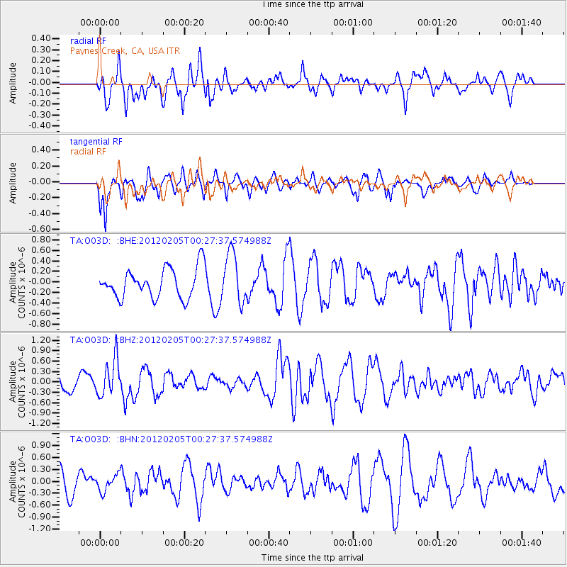
Signal To Noise
| Channel | StoN | STA | LTA |
| TA:O03D: :BHZ:20120205T00:27:37.574988Z | 2.5620944 | 5.453962E-7 | 2.1287123E-7 |
| TA:O03D: :BHN:20120205T00:27:37.574988Z | 0.5802194 | 2.1801141E-7 | 3.7573963E-7 |
| TA:O03D: :BHE:20120205T00:27:37.574988Z | 1.7329375 | 4.822706E-7 | 2.782966E-7 |
| Arrivals |
| Ps | |
| PpPs | |
| PsPs/PpSs | |


