You are here: Home > Network List > AU - Australian Seismological Centre Stations List
> Station KNRA Kunnunarra, Western Australia > Earthquake Result Viewer
KNRA Kunnunarra, Western Australia - Earthquake Result Viewer
| Earthquake location: |
Vanuatu Islands |
| Earthquake latitude/longitude: |
-17.9/167.2 |
| Earthquake time(UTC): |
2012/02/05 (036) 16:40:39 GMT |
| Earthquake Depth: |
8.0 km |
| Earthquake Magnitude: |
5.9 MB, 5.7 MS, 6.1 MW, 6.0 MW |
| Earthquake Catalog/Contributor: |
WHDF/NEIC |
|
| Network: |
AU Australian Seismological Centre |
| Station: |
KNRA Kunnunarra, Western Australia |
| Lat/Lon: |
15.68 S/128.76 E |
| Elevation: |
101 m |
|
| Distance: |
36.8 deg |
| Az: |
267.648 deg |
| Baz: |
99.103 deg |
| Ray Param: |
0.07646301 |
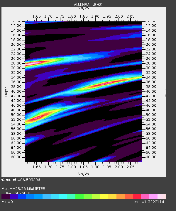
| Estimated Moho Depth: |
28.25 km |
| Estimated Crust Vp/Vs: |
1.61 |
| Assumed Crust Vp: |
6.397 km/s |
| Estimated Crust Vs: |
3.98 km/s |
| Estimated Crust Poisson's Ratio: |
0.18 |
|
| Radial Match: |
86.599396 % |
| Radial Bump: |
400 |
| Transverse Match: |
54.86937 % |
| Transverse Bump: |
400 |
| SOD ConfigId: |
436445 |
| Insert Time: |
2012-04-21 04:58:39.616 +0000 |
| GWidth: |
2.5 |
| Max Bumps: |
400 |
| Tol: |
0.001 |
|

Signal To Noise
| Channel | StoN | STA | LTA |
| AU:KNRA: :BHZ:20120205T16:47:16.945004Z | 6.555746 | 2.318397E-6 | 3.536435E-7 |
| AU:KNRA: :BHN:20120205T16:47:16.945004Z | 2.045835 | 4.4519044E-7 | 2.1760818E-7 |
| AU:KNRA: :BHE:20120205T16:47:16.945004Z | 4.9408383 | 1.6389805E-6 | 3.3172117E-7 |
| Arrivals |
| Ps | 2.9 SECOND |
| PpPs | 11 SECOND |
| PsPs/PpSs | 14 SECOND |


