You are here: Home > Network List > CI - Caltech Regional Seismic Network Stations List
> Station FUR Furnace Creek, CA, USA > Earthquake Result Viewer
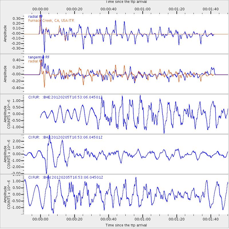
FUR Furnace Creek, CA, USA - Earthquake Result Viewer
*The percent match for this event was below the threshold and hence no stack was calculated.
| Earthquake location: |
Vanuatu Islands |
| Earthquake latitude/longitude: |
-17.9/167.2 |
| Earthquake time(UTC): |
2012/02/05 (036) 16:40:39 GMT |
| Earthquake Depth: |
8.0 km |
| Earthquake Magnitude: |
5.9 MB, 5.7 MS, 6.1 MW, 6.0 MW |
| Earthquake Catalog/Contributor: |
WHDF/NEIC |
|
| Network: |
CI Caltech Regional Seismic Network |
| Station: |
FUR Furnace Creek, CA, USA |
| Lat/Lon: |
36.47 N/116.86 W |
| Elevation: |
-37.0 m |
|
| Distance: |
89.7 deg |
| Az: |
51.432 deg |
| Baz: |
247.416 deg |
| Ray Param: |
$rayparam |
*The percent match for this event was below the threshold and hence was not used in the summary stack. |
|
| Radial Match: |
82.2138 % |
| Radial Bump: |
400 |
| Transverse Match: |
69.60377 % |
| Transverse Bump: |
400 |
| SOD ConfigId: |
436445 |
| Insert Time: |
2012-04-21 05:06:20.429 +0000 |
| GWidth: |
2.5 |
| Max Bumps: |
400 |
| Tol: |
0.001 |
|
Signal To Noise
| Channel | StoN | STA | LTA |
| CI:FUR: :BHZ:20120205T16:53:06.04501Z | 4.2099667 | 1.1665909E-6 | 2.7710217E-7 |
| CI:FUR: :BHN:20120205T16:53:06.04501Z | 1.1957428 | 7.7185774E-7 | 6.455048E-7 |
| CI:FUR: :BHE:20120205T16:53:06.04501Z | 1.504259 | 4.95771E-7 | 3.295782E-7 |
| Arrivals |
| Ps | |
| PpPs | |
| PsPs/PpSs | |


