You are here: Home > Network List > TA - USArray Transportable Network (new EarthScope stations) Stations List
> Station 121A Cookes Peak, Deming, NM, USA > Earthquake Result Viewer
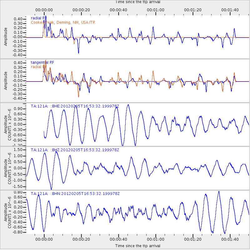
121A Cookes Peak, Deming, NM, USA - Earthquake Result Viewer
*The percent match for this event was below the threshold and hence no stack was calculated.
| Earthquake location: |
Vanuatu Islands |
| Earthquake latitude/longitude: |
-17.9/167.2 |
| Earthquake time(UTC): |
2012/02/05 (036) 16:40:39 GMT |
| Earthquake Depth: |
8.0 km |
| Earthquake Magnitude: |
5.9 MB, 5.7 MS, 6.1 MW, 6.0 MW |
| Earthquake Catalog/Contributor: |
WHDF/NEIC |
|
| Network: |
TA USArray Transportable Network (new EarthScope stations) |
| Station: |
121A Cookes Peak, Deming, NM, USA |
| Lat/Lon: |
32.53 N/107.79 W |
| Elevation: |
1652 m |
|
| Distance: |
95.4 deg |
| Az: |
57.694 deg |
| Baz: |
252.268 deg |
| Ray Param: |
$rayparam |
*The percent match for this event was below the threshold and hence was not used in the summary stack. |
|
| Radial Match: |
77.96872 % |
| Radial Bump: |
400 |
| Transverse Match: |
56.565308 % |
| Transverse Bump: |
400 |
| SOD ConfigId: |
436445 |
| Insert Time: |
2012-04-21 05:12:46.447 +0000 |
| GWidth: |
2.5 |
| Max Bumps: |
400 |
| Tol: |
0.001 |
|
Signal To Noise
| Channel | StoN | STA | LTA |
| TA:121A: :BHZ:20120205T16:53:32.199978Z | 3.2159483 | 1.0367356E-6 | 3.2237324E-7 |
| TA:121A: :BHN:20120205T16:53:32.199978Z | 1.4832982 | 4.120902E-7 | 2.778202E-7 |
| TA:121A: :BHE:20120205T16:53:32.199978Z | 0.70022625 | 4.77005E-7 | 6.812155E-7 |
| Arrivals |
| Ps | |
| PpPs | |
| PsPs/PpSs | |


