You are here: Home > Network List > TA - USArray Transportable Network (new EarthScope stations) Stations List
> Station TPFO Pinon Flats, CA, USA > Earthquake Result Viewer
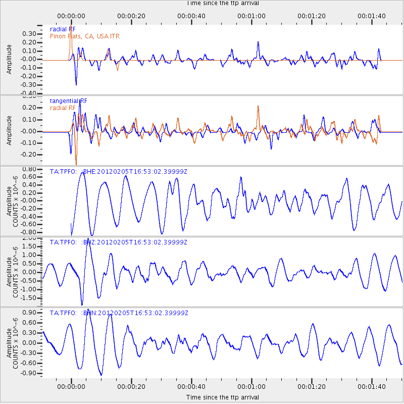
TPFO Pinon Flats, CA, USA - Earthquake Result Viewer
*The percent match for this event was below the threshold and hence no stack was calculated.
| Earthquake location: |
Vanuatu Islands |
| Earthquake latitude/longitude: |
-17.9/167.2 |
| Earthquake time(UTC): |
2012/02/05 (036) 16:40:39 GMT |
| Earthquake Depth: |
8.0 km |
| Earthquake Magnitude: |
5.9 MB, 5.7 MS, 6.1 MW, 6.0 MW |
| Earthquake Catalog/Contributor: |
WHDF/NEIC |
|
| Network: |
TA USArray Transportable Network (new EarthScope stations) |
| Station: |
TPFO Pinon Flats, CA, USA |
| Lat/Lon: |
33.61 N/116.45 W |
| Elevation: |
1275 m |
|
| Distance: |
88.9 deg |
| Az: |
54.198 deg |
| Baz: |
247.684 deg |
| Ray Param: |
$rayparam |
*The percent match for this event was below the threshold and hence was not used in the summary stack. |
|
| Radial Match: |
60.106674 % |
| Radial Bump: |
400 |
| Transverse Match: |
63.70165 % |
| Transverse Bump: |
376 |
| SOD ConfigId: |
436445 |
| Insert Time: |
2012-04-21 05:15:14.291 +0000 |
| GWidth: |
2.5 |
| Max Bumps: |
400 |
| Tol: |
0.001 |
|
Signal To Noise
| Channel | StoN | STA | LTA |
| TA:TPFO: :BHZ:20120205T16:53:02.39999Z | 2.4369884 | 7.6661473E-7 | 3.1457463E-7 |
| TA:TPFO: :BHN:20120205T16:53:02.39999Z | 2.048895 | 5.2555174E-7 | 2.56505E-7 |
| TA:TPFO: :BHE:20120205T16:53:02.39999Z | 1.0666928 | 4.949095E-7 | 4.6396624E-7 |
| Arrivals |
| Ps | |
| PpPs | |
| PsPs/PpSs | |


