You are here: Home > Network List > UW - Pacific Northwest Regional Seismic Network Stations List
> Station WOLL Wollman Farm, Schrag, WA, USA > Earthquake Result Viewer
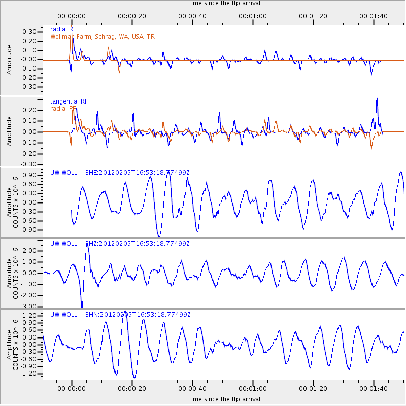
WOLL Wollman Farm, Schrag, WA, USA - Earthquake Result Viewer
*The percent match for this event was below the threshold and hence no stack was calculated.
| Earthquake location: |
Vanuatu Islands |
| Earthquake latitude/longitude: |
-17.9/167.2 |
| Earthquake time(UTC): |
2012/02/05 (036) 16:40:39 GMT |
| Earthquake Depth: |
8.0 km |
| Earthquake Magnitude: |
5.9 MB, 5.7 MS, 6.1 MW, 6.0 MW |
| Earthquake Catalog/Contributor: |
WHDF/NEIC |
|
| Network: |
UW Pacific Northwest Regional Seismic Network |
| Station: |
WOLL Wollman Farm, Schrag, WA, USA |
| Lat/Lon: |
47.06 N/118.92 W |
| Elevation: |
385 m |
|
| Distance: |
92.4 deg |
| Az: |
41.097 deg |
| Baz: |
246.236 deg |
| Ray Param: |
$rayparam |
*The percent match for this event was below the threshold and hence was not used in the summary stack. |
|
| Radial Match: |
35.577957 % |
| Radial Bump: |
339 |
| Transverse Match: |
60.717728 % |
| Transverse Bump: |
209 |
| SOD ConfigId: |
436445 |
| Insert Time: |
2012-04-21 05:17:01.507 +0000 |
| GWidth: |
2.5 |
| Max Bumps: |
400 |
| Tol: |
0.001 |
|
Signal To Noise
| Channel | StoN | STA | LTA |
| UW:WOLL: :BHZ:20120205T16:53:18.77499Z | 2.5265884 | 1.2754549E-6 | 5.048131E-7 |
| UW:WOLL: :BHN:20120205T16:53:18.77499Z | 0.2811343 | 1.7563718E-7 | 6.2474476E-7 |
| UW:WOLL: :BHE:20120205T16:53:18.77499Z | 2.046608 | 7.04673E-7 | 3.4431267E-7 |
| Arrivals |
| Ps | |
| PpPs | |
| PsPs/PpSs | |


