You are here: Home > Network List > G - GEOSCOPE Stations List
> Station DZM Dzumac, New Caledonia > Earthquake Result Viewer
DZM Dzumac, New Caledonia - Earthquake Result Viewer
| Earthquake location: |
Negros, Philippines |
| Earthquake latitude/longitude: |
10.0/123.2 |
| Earthquake time(UTC): |
2012/02/06 (037) 03:49:12 GMT |
| Earthquake Depth: |
11 km |
| Earthquake Magnitude: |
6.3 MB, 6.6 MS, 6.7 MW, 6.7 MW |
| Earthquake Catalog/Contributor: |
WHDF/NEIC |
|
| Network: |
G GEOSCOPE |
| Station: |
DZM Dzumac, New Caledonia |
| Lat/Lon: |
22.07 S/166.44 E |
| Elevation: |
878 m |
|
| Distance: |
53.0 deg |
| Az: |
127.329 deg |
| Baz: |
302.394 deg |
| Ray Param: |
0.06636096 |
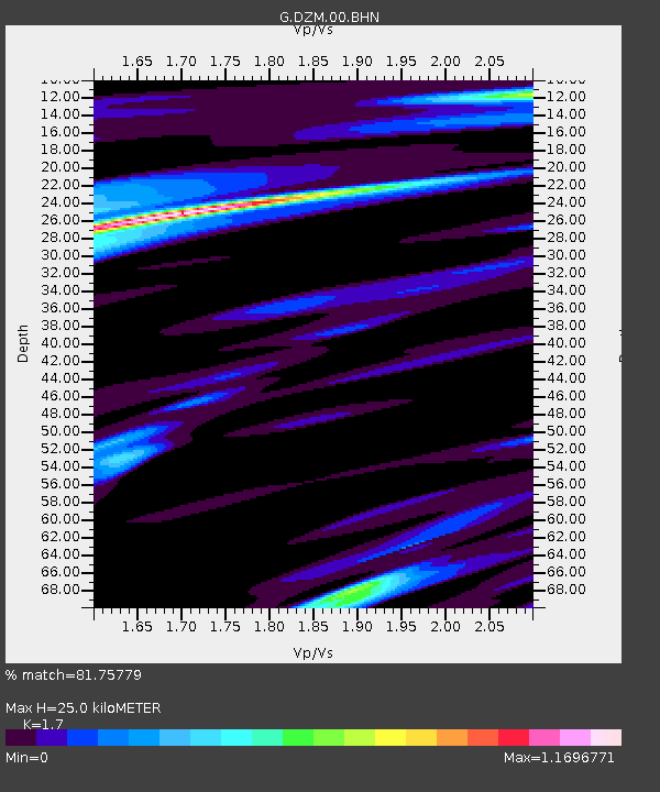
| Estimated Moho Depth: |
25.0 km |
| Estimated Crust Vp/Vs: |
1.70 |
| Assumed Crust Vp: |
5.14 km/s |
| Estimated Crust Vs: |
3.024 km/s |
| Estimated Crust Poisson's Ratio: |
0.24 |
|
| Radial Match: |
81.75779 % |
| Radial Bump: |
400 |
| Transverse Match: |
66.227745 % |
| Transverse Bump: |
368 |
| SOD ConfigId: |
436445 |
| Insert Time: |
2012-04-21 05:24:13.746 +0000 |
| GWidth: |
2.5 |
| Max Bumps: |
400 |
| Tol: |
0.001 |
|
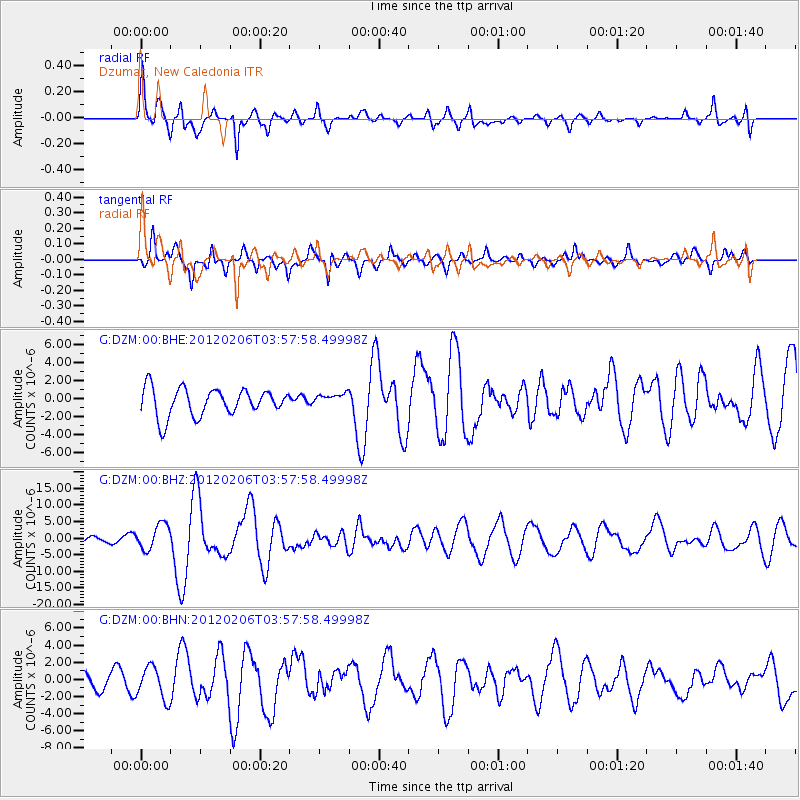
Signal To Noise
| Channel | StoN | STA | LTA |
| G:DZM:00:BHZ:20120206T03:57:58.49998Z | 4.590104 | 3.848463E-6 | 8.384261E-7 |
| G:DZM:00:BHN:20120206T03:57:58.49998Z | 1.0841362 | 1.9060217E-6 | 1.7581016E-6 |
| G:DZM:00:BHE:20120206T03:57:58.49998Z | 0.4845436 | 7.4328705E-7 | 1.5339942E-6 |
| Arrivals |
| Ps | 3.5 SECOND |
| PpPs | 13 SECOND |
| PsPs/PpSs | 16 SECOND |


