You are here: Home > Network List > G - GEOSCOPE Stations List
> Station PPTF Pamatai - Papeete - Tahiti island - French Polynesia, France > Earthquake Result Viewer
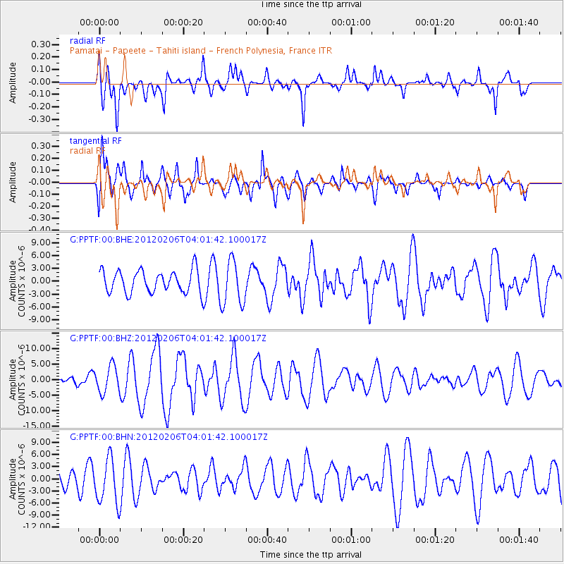
PPTF Pamatai - Papeete - Tahiti island - French Polynesia, France - Earthquake Result Viewer
*The percent match for this event was below the threshold and hence no stack was calculated.
| Earthquake location: |
Negros, Philippines |
| Earthquake latitude/longitude: |
10.0/123.2 |
| Earthquake time(UTC): |
2012/02/06 (037) 03:49:12 GMT |
| Earthquake Depth: |
11 km |
| Earthquake Magnitude: |
6.3 MB, 6.6 MS, 6.7 MW, 6.7 MW |
| Earthquake Catalog/Contributor: |
WHDF/NEIC |
|
| Network: |
G GEOSCOPE |
| Station: |
PPTF Pamatai - Papeete - Tahiti island - French Polynesia, France |
| Lat/Lon: |
17.59 S/149.57 W |
| Elevation: |
705 m |
|
| Distance: |
90.4 deg |
| Az: |
107.687 deg |
| Baz: |
280.303 deg |
| Ray Param: |
$rayparam |
*The percent match for this event was below the threshold and hence was not used in the summary stack. |
|
| Radial Match: |
58.74011 % |
| Radial Bump: |
400 |
| Transverse Match: |
81.64029 % |
| Transverse Bump: |
400 |
| SOD ConfigId: |
436445 |
| Insert Time: |
2012-04-21 05:24:16.329 +0000 |
| GWidth: |
2.5 |
| Max Bumps: |
400 |
| Tol: |
0.001 |
|
Signal To Noise
| Channel | StoN | STA | LTA |
| G:PPTF:00:BHZ:20120206T04:01:42.100017Z | 1.3370243 | 4.379855E-6 | 3.2758228E-6 |
| G:PPTF:00:BHN:20120206T04:01:42.100017Z | 2.3207097 | 5.80845E-6 | 2.5028764E-6 |
| G:PPTF:00:BHE:20120206T04:01:42.100017Z | 2.0133483 | 5.2634896E-6 | 2.6142966E-6 |
| Arrivals |
| Ps | |
| PpPs | |
| PsPs/PpSs | |


