You are here: Home > Network List > US - United States National Seismic Network Stations List
> Station MSO Missoula, Montana, USA > Earthquake Result Viewer
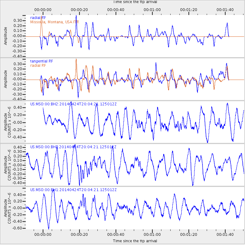
MSO Missoula, Montana, USA - Earthquake Result Viewer
*The percent match for this event was below the threshold and hence no stack was calculated.
| Earthquake location: |
South Of Fiji Islands |
| Earthquake latitude/longitude: |
-23.9/-176.7 |
| Earthquake time(UTC): |
2014/04/24 (114) 19:51:59 GMT |
| Earthquake Depth: |
66 km |
| Earthquake Magnitude: |
5.9 M |
| Earthquake Catalog/Contributor: |
NEIC PDE/NEIC ALERT |
|
| Network: |
US United States National Seismic Network |
| Station: |
MSO Missoula, Montana, USA |
| Lat/Lon: |
46.83 N/113.94 W |
| Elevation: |
1264 m |
|
| Distance: |
90.4 deg |
| Az: |
37.64 deg |
| Baz: |
234.464 deg |
| Ray Param: |
$rayparam |
*The percent match for this event was below the threshold and hence was not used in the summary stack. |
|
| Radial Match: |
47.316917 % |
| Radial Bump: |
349 |
| Transverse Match: |
43.12719 % |
| Transverse Bump: |
394 |
| SOD ConfigId: |
3390531 |
| Insert Time: |
2019-04-11 14:46:32.431 +0000 |
| GWidth: |
2.5 |
| Max Bumps: |
400 |
| Tol: |
0.001 |
|
Signal To Noise
| Channel | StoN | STA | LTA |
| US:MSO:00:BHZ:20140424T20:04:21.125012Z | 0.9470567 | 1.9737895E-7 | 2.0841303E-7 |
| US:MSO:00:BH1:20140424T20:04:21.125012Z | 2.2438934 | 3.3252064E-7 | 1.4818914E-7 |
| US:MSO:00:BH2:20140424T20:04:21.125012Z | 1.2857921 | 2.3515315E-7 | 1.8288581E-7 |
| Arrivals |
| Ps | |
| PpPs | |
| PsPs/PpSs | |


