You are here: Home > Network List > YT07 - POLENET Stations List
> Station SURP SURP > Earthquake Result Viewer
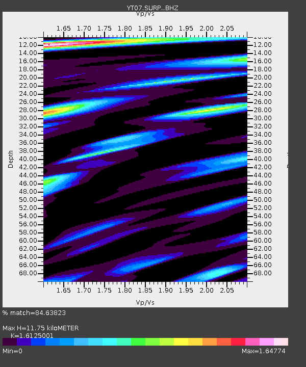
SURP SURP - Earthquake Result Viewer
| Earthquake location: |
South Of Fiji Islands |
| Earthquake latitude/longitude: |
-23.9/-176.7 |
| Earthquake time(UTC): |
2014/04/24 (114) 19:51:59 GMT |
| Earthquake Depth: |
66 km |
| Earthquake Magnitude: |
5.9 M |
| Earthquake Catalog/Contributor: |
NEIC PDE/NEIC ALERT |
|
| Network: |
YT POLENET |
| Station: |
SURP SURP |
| Lat/Lon: |
84.72 S/171.20 W |
| Elevation: |
407 m |
|
| Distance: |
60.9 deg |
| Az: |
179.414 deg |
| Baz: |
354.201 deg |
| Ray Param: |
0.06105585 |
| Estimated Moho Depth: |
11.75 km |
| Estimated Crust Vp/Vs: |
1.61 |
| Assumed Crust Vp: |
6.245 km/s |
| Estimated Crust Vs: |
3.873 km/s |
| Estimated Crust Poisson's Ratio: |
0.19 |
|
| Radial Match: |
84.63823 % |
| Radial Bump: |
400 |
| Transverse Match: |
70.05649 % |
| Transverse Bump: |
400 |
| SOD ConfigId: |
3390531 |
| Insert Time: |
2019-04-11 14:47:25.761 +0000 |
| GWidth: |
2.5 |
| Max Bumps: |
400 |
| Tol: |
0.001 |
|

Signal To Noise
| Channel | StoN | STA | LTA |
| YT:SURP: :BHZ:20140424T20:01:33.425Z | 5.7050133 | 1.199401E-6 | 2.1023634E-7 |
| YT:SURP: :BHN:20140424T20:01:33.425Z | 5.466796 | 6.866247E-7 | 1.2559912E-7 |
| YT:SURP: :BHE:20140424T20:01:33.425Z | 0.8813927 | 1.420312E-7 | 1.6114404E-7 |
| Arrivals |
| Ps | 1.2 SECOND |
| PpPs | 4.7 SECOND |
| PsPs/PpSs | 5.9 SECOND |


