You are here: Home > Network List > AU - Australian Seismological Centre Stations List
> Station FORT Forrest, Western Australia > Earthquake Result Viewer
FORT Forrest, Western Australia - Earthquake Result Viewer
| Earthquake location: |
Negros, Philippines |
| Earthquake latitude/longitude: |
9.9/123.1 |
| Earthquake time(UTC): |
2012/02/06 (037) 10:10:19 GMT |
| Earthquake Depth: |
9.0 km |
| Earthquake Magnitude: |
5.8 MB, 5.9 MS, 6.0 MW, 6.0 MW |
| Earthquake Catalog/Contributor: |
WHDF/NEIC |
|
| Network: |
AU Australian Seismological Centre |
| Station: |
FORT Forrest, Western Australia |
| Lat/Lon: |
30.78 S/128.06 E |
| Elevation: |
165 m |
|
| Distance: |
40.7 deg |
| Az: |
173.444 deg |
| Baz: |
352.489 deg |
| Ray Param: |
0.07424391 |
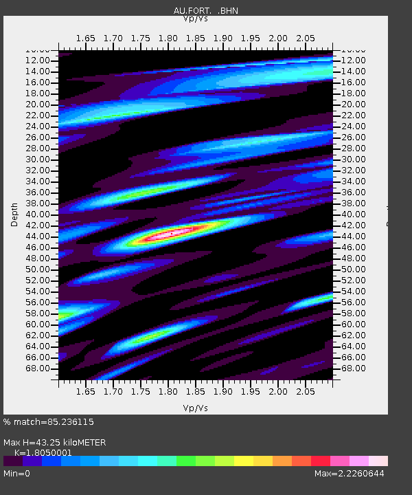
| Estimated Moho Depth: |
43.25 km |
| Estimated Crust Vp/Vs: |
1.81 |
| Assumed Crust Vp: |
6.479 km/s |
| Estimated Crust Vs: |
3.59 km/s |
| Estimated Crust Poisson's Ratio: |
0.28 |
|
| Radial Match: |
85.236115 % |
| Radial Bump: |
400 |
| Transverse Match: |
64.89575 % |
| Transverse Bump: |
400 |
| SOD ConfigId: |
436445 |
| Insert Time: |
2012-04-21 05:36:15.310 +0000 |
| GWidth: |
2.5 |
| Max Bumps: |
400 |
| Tol: |
0.001 |
|

Signal To Noise
| Channel | StoN | STA | LTA |
| AU:FORT: :BHZ:20120206T10:17:29.844995Z | 5.517441 | 1.4389107E-5 | 2.6079315E-6 |
| AU:FORT: :BHN:20120206T10:17:29.844995Z | 2.6671717 | 8.293335E-6 | 3.1094114E-6 |
| AU:FORT: :BHE:20120206T10:17:29.844995Z | 0.841443 | 2.622229E-6 | 3.1163477E-6 |
| Arrivals |
| Ps | 5.8 SECOND |
| PpPs | 17 SECOND |
| PsPs/PpSs | 23 SECOND |


