You are here: Home > Network List > ZJ12 - Transantarctic Mountains Northern Network Stations List
> Station SAMH East Antarctica > Earthquake Result Viewer
SAMH East Antarctica - Earthquake Result Viewer
| Earthquake location: |
South Of Fiji Islands |
| Earthquake latitude/longitude: |
-23.9/-176.7 |
| Earthquake time(UTC): |
2014/04/24 (114) 19:51:59 GMT |
| Earthquake Depth: |
66 km |
| Earthquake Magnitude: |
5.9 M |
| Earthquake Catalog/Contributor: |
NEIC PDE/NEIC ALERT |
|
| Network: |
ZJ Transantarctic Mountains Northern Network |
| Station: |
SAMH East Antarctica |
| Lat/Lon: |
75.20 S/154.00 E |
| Elevation: |
2087 m |
|
| Distance: |
53.5 deg |
| Az: |
188.995 deg |
| Baz: |
33.819 deg |
| Ray Param: |
0.06588874 |
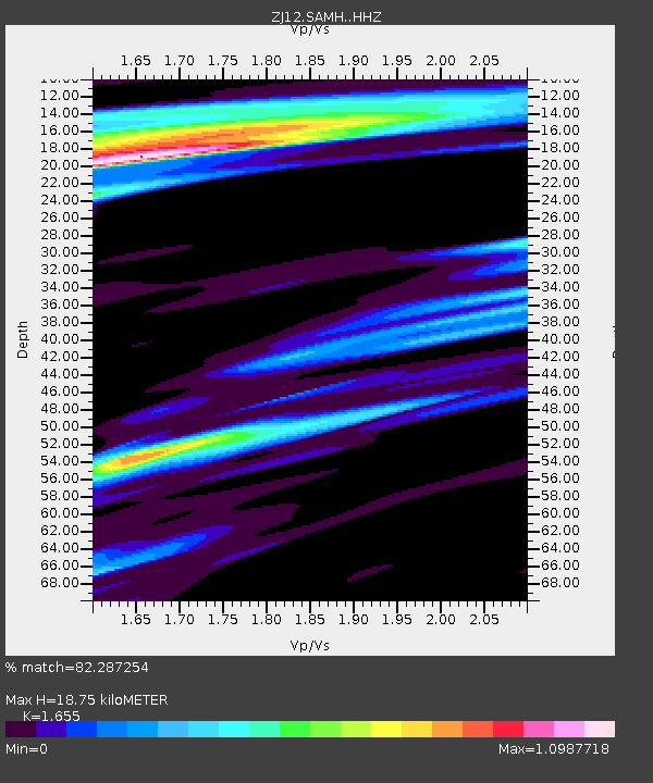
| Estimated Moho Depth: |
18.75 km |
| Estimated Crust Vp/Vs: |
1.65 |
| Assumed Crust Vp: |
6.262 km/s |
| Estimated Crust Vs: |
3.784 km/s |
| Estimated Crust Poisson's Ratio: |
0.21 |
|
| Radial Match: |
82.287254 % |
| Radial Bump: |
400 |
| Transverse Match: |
72.739655 % |
| Transverse Bump: |
400 |
| SOD ConfigId: |
3390531 |
| Insert Time: |
2019-04-11 14:47:42.783 +0000 |
| GWidth: |
2.5 |
| Max Bumps: |
400 |
| Tol: |
0.001 |
|

Signal To Noise
| Channel | StoN | STA | LTA |
| ZJ:SAMH: :HHZ:20140424T20:00:41.300Z | 16.660141 | 2.4340409E-6 | 1.4609967E-7 |
| ZJ:SAMH: :HHN:20140424T20:00:41.300Z | 2.7107534 | 4.8529375E-7 | 1.7902542E-7 |
| ZJ:SAMH: :HHE:20140424T20:00:41.300Z | 1.4252136 | 3.7571172E-7 | 2.6361784E-7 |
| Arrivals |
| Ps | 2.1 SECOND |
| PpPs | 7.5 SECOND |
| PsPs/PpSs | 9.6 SECOND |


