You are here: Home > Network List > UU - University of Utah Regional Network Stations List
> Station CCUT Cedar City, UT, USA > Earthquake Result Viewer
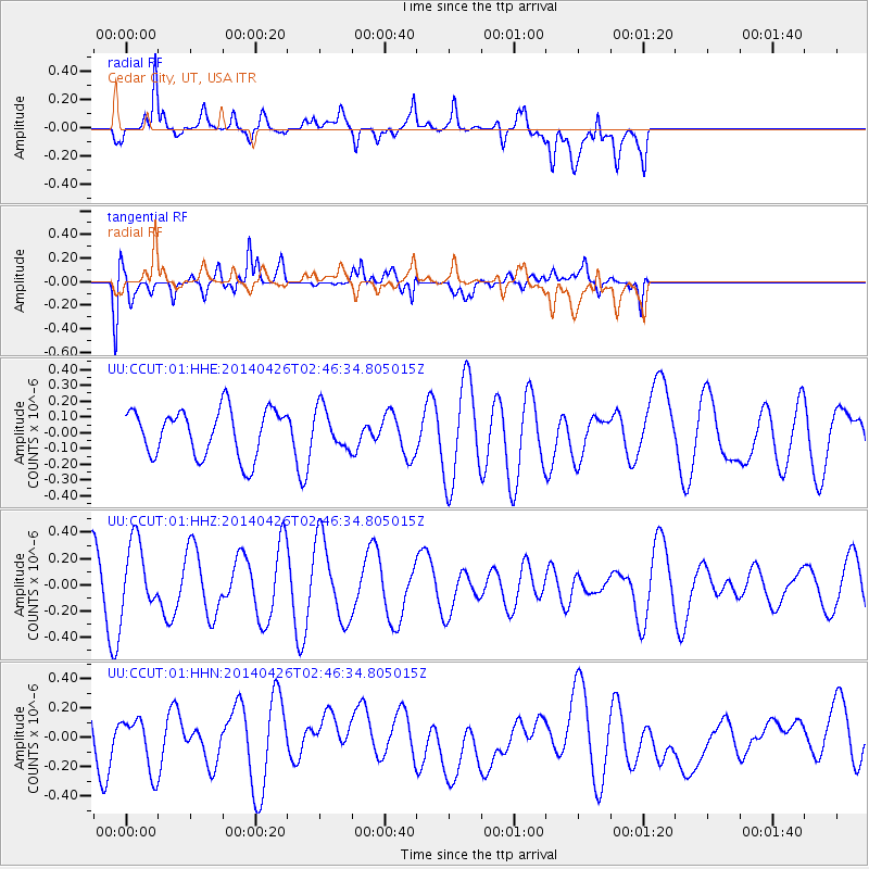
CCUT Cedar City, UT, USA - Earthquake Result Viewer
*The percent match for this event was below the threshold and hence no stack was calculated.
| Earthquake location: |
Pacific-Antarctic Ridge |
| Earthquake latitude/longitude: |
-56.3/-143.9 |
| Earthquake time(UTC): |
2014/04/26 (116) 02:33:34 GMT |
| Earthquake Depth: |
0.0 km |
| Earthquake Magnitude: |
5.7 MWC, 5.7 MWC |
| Earthquake Catalog/Contributor: |
NEIC PDE/NEIC COMCAT |
|
| Network: |
UU University of Utah Regional Network |
| Station: |
CCUT Cedar City, UT, USA |
| Lat/Lon: |
37.55 N/113.36 W |
| Elevation: |
2127 m |
|
| Distance: |
97.1 deg |
| Az: |
24.012 deg |
| Baz: |
196.561 deg |
| Ray Param: |
$rayparam |
*The percent match for this event was below the threshold and hence was not used in the summary stack. |
|
| Radial Match: |
65.02264 % |
| Radial Bump: |
400 |
| Transverse Match: |
56.028698 % |
| Transverse Bump: |
400 |
| SOD ConfigId: |
3390531 |
| Insert Time: |
2019-04-11 14:55:00.248 +0000 |
| GWidth: |
2.5 |
| Max Bumps: |
400 |
| Tol: |
0.001 |
|
Signal To Noise
| Channel | StoN | STA | LTA |
| UU:CCUT:01:HHZ:20140426T02:46:34.805015Z | 1.1343101 | 2.5877773E-7 | 2.2813666E-7 |
| UU:CCUT:01:HHN:20140426T02:46:34.805015Z | 1.3069533 | 1.7761634E-7 | 1.3590106E-7 |
| UU:CCUT:01:HHE:20140426T02:46:34.805015Z | 0.74573904 | 1.09733776E-7 | 1.4714769E-7 |
| Arrivals |
| Ps | |
| PpPs | |
| PsPs/PpSs | |


