You are here: Home > Network List > AZ - ANZA Regional Network Stations List
> Station SMER AZ.SMER > Earthquake Result Viewer
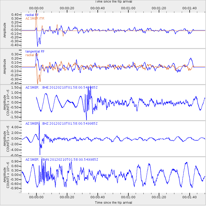
SMER AZ.SMER - Earthquake Result Viewer
*The percent match for this event was below the threshold and hence no stack was calculated.
| Earthquake location: |
Fiji Islands Region |
| Earthquake latitude/longitude: |
-18.0/-178.5 |
| Earthquake time(UTC): |
2012/02/10 (041) 01:47:34 GMT |
| Earthquake Depth: |
582 km |
| Earthquake Magnitude: |
6.0 MB, 5.9 MW, 6.0 MW |
| Earthquake Catalog/Contributor: |
WHDF/NEIC |
|
| Network: |
AZ ANZA Regional Network |
| Station: |
SMER AZ.SMER |
| Lat/Lon: |
33.46 N/117.17 W |
| Elevation: |
355 m |
|
| Distance: |
77.7 deg |
| Az: |
48.682 deg |
| Baz: |
238.774 deg |
| Ray Param: |
$rayparam |
*The percent match for this event was below the threshold and hence was not used in the summary stack. |
|
| Radial Match: |
68.51912 % |
| Radial Bump: |
397 |
| Transverse Match: |
70.646255 % |
| Transverse Bump: |
400 |
| SOD ConfigId: |
436445 |
| Insert Time: |
2012-04-21 06:07:35.226 +0000 |
| GWidth: |
2.5 |
| Max Bumps: |
400 |
| Tol: |
0.001 |
|
Signal To Noise
| Channel | StoN | STA | LTA |
| AZ:SMER: :BHZ:20120210T01:58:00.549985Z | 8.471416 | 2.175489E-6 | 2.5680345E-7 |
| AZ:SMER: :BHN:20120210T01:58:00.549985Z | 1.8441312 | 5.3294633E-7 | 2.889959E-7 |
| AZ:SMER: :BHE:20120210T01:58:00.549985Z | 1.640476 | 7.8458174E-7 | 4.782647E-7 |
| Arrivals |
| Ps | |
| PpPs | |
| PsPs/PpSs | |


