You are here: Home > Network List > BK - Berkeley Digital Seismograph Network Stations List
> Station HUMO Hull Mountain, OR > Earthquake Result Viewer
HUMO Hull Mountain, OR - Earthquake Result Viewer
*The percent match for this event was below the threshold and hence no stack was calculated.
| Earthquake location: |
Fiji Islands Region |
| Earthquake latitude/longitude: |
-18.0/-178.5 |
| Earthquake time(UTC): |
2012/02/10 (041) 01:47:34 GMT |
| Earthquake Depth: |
582 km |
| Earthquake Magnitude: |
6.0 MB, 5.9 MW, 6.0 MW |
| Earthquake Catalog/Contributor: |
WHDF/NEIC |
|
| Network: |
BK Berkeley Digital Seismograph Network |
| Station: |
HUMO Hull Mountain, OR |
| Lat/Lon: |
42.61 N/122.96 W |
| Elevation: |
555 m |
|
| Distance: |
79.0 deg |
| Az: |
38.348 deg |
| Baz: |
233.122 deg |
| Ray Param: |
$rayparam |
*The percent match for this event was below the threshold and hence was not used in the summary stack. |
|
| Radial Match: |
67.85075 % |
| Radial Bump: |
400 |
| Transverse Match: |
41.56381 % |
| Transverse Bump: |
400 |
| SOD ConfigId: |
436445 |
| Insert Time: |
2012-04-21 06:07:56.062 +0000 |
| GWidth: |
2.5 |
| Max Bumps: |
400 |
| Tol: |
0.001 |
|
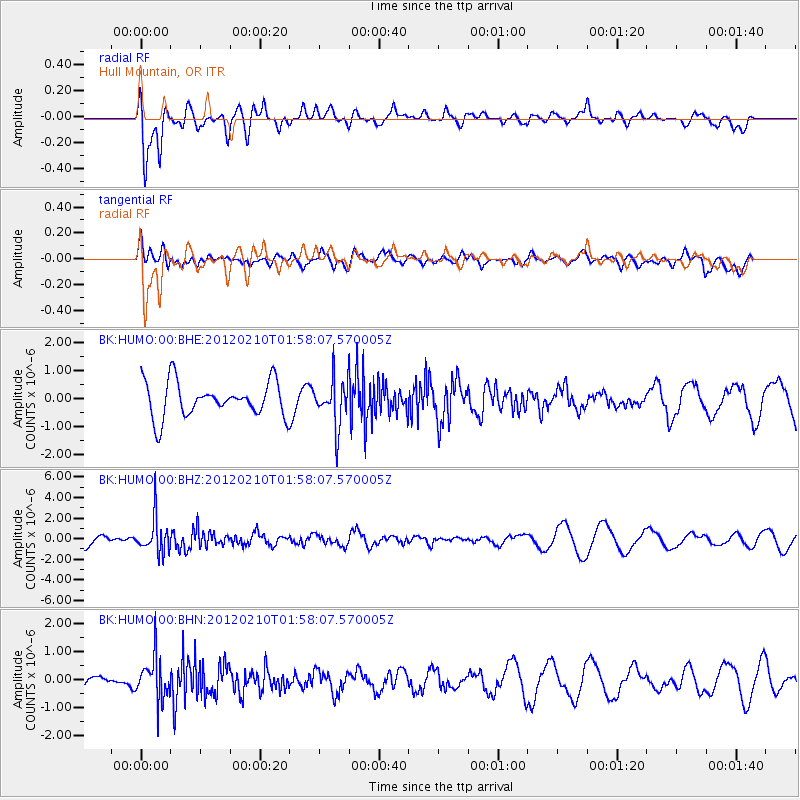
Signal To Noise
| Channel | StoN | STA | LTA |
| BK:HUMO:00:BHZ:20120210T01:58:07.570005Z | 3.2200527 | 1.6959603E-6 | 5.2668713E-7 |
| BK:HUMO:00:BHN:20120210T01:58:07.570005Z | 2.929336 | 7.6337545E-7 | 2.6059675E-7 |
| BK:HUMO:00:BHE:20120210T01:58:07.570005Z | 1.3283017 | 8.298061E-7 | 6.247121E-7 |
| Arrivals |
| Ps | |
| PpPs | |
| PsPs/PpSs | |


