You are here: Home > Network List > CI - Caltech Regional Seismic Network Stations List
> Station MUR Murrieta > Earthquake Result Viewer
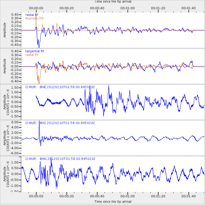
MUR Murrieta - Earthquake Result Viewer
*The percent match for this event was below the threshold and hence no stack was calculated.
| Earthquake location: |
Fiji Islands Region |
| Earthquake latitude/longitude: |
-18.0/-178.5 |
| Earthquake time(UTC): |
2012/02/10 (041) 01:47:34 GMT |
| Earthquake Depth: |
582 km |
| Earthquake Magnitude: |
6.0 MB, 5.9 MW, 6.0 MW |
| Earthquake Catalog/Contributor: |
WHDF/NEIC |
|
| Network: |
CI Caltech Regional Seismic Network |
| Station: |
MUR Murrieta |
| Lat/Lon: |
33.60 N/117.20 W |
| Elevation: |
562 m |
|
| Distance: |
77.8 deg |
| Az: |
48.547 deg |
| Baz: |
238.732 deg |
| Ray Param: |
$rayparam |
*The percent match for this event was below the threshold and hence was not used in the summary stack. |
|
| Radial Match: |
62.841248 % |
| Radial Bump: |
379 |
| Transverse Match: |
42.43242 % |
| Transverse Bump: |
400 |
| SOD ConfigId: |
436445 |
| Insert Time: |
2012-04-21 06:11:26.496 +0000 |
| GWidth: |
2.5 |
| Max Bumps: |
400 |
| Tol: |
0.001 |
|
Signal To Noise
| Channel | StoN | STA | LTA |
| CI:MUR: :BHZ:20120210T01:58:00.845029Z | 4.9679084 | 1.7004583E-6 | 3.422886E-7 |
| CI:MUR: :BHN:20120210T01:58:00.845029Z | 1.0449882 | 4.139797E-7 | 3.961573E-7 |
| CI:MUR: :BHE:20120210T01:58:00.845029Z | 1.9875727 | 4.7467634E-7 | 2.3882214E-7 |
| Arrivals |
| Ps | |
| PpPs | |
| PsPs/PpSs | |


