You are here: Home > Network List > TA - USArray Transportable Network (new EarthScope stations) Stations List
> Station J05D Fort Rock, OR, USA > Earthquake Result Viewer
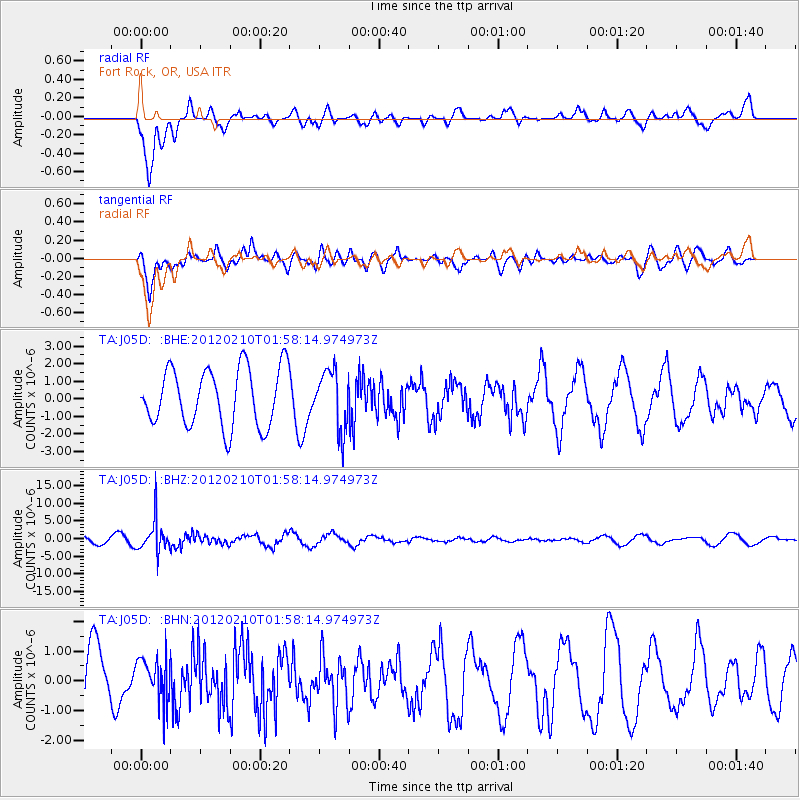
J05D Fort Rock, OR, USA - Earthquake Result Viewer
*The percent match for this event was below the threshold and hence no stack was calculated.
| Earthquake location: |
Fiji Islands Region |
| Earthquake latitude/longitude: |
-18.0/-178.5 |
| Earthquake time(UTC): |
2012/02/10 (041) 01:47:34 GMT |
| Earthquake Depth: |
582 km |
| Earthquake Magnitude: |
6.0 MB, 5.9 MW, 6.0 MW |
| Earthquake Catalog/Contributor: |
WHDF/NEIC |
|
| Network: |
TA USArray Transportable Network (new EarthScope stations) |
| Station: |
J05D Fort Rock, OR, USA |
| Lat/Lon: |
43.28 N/121.23 W |
| Elevation: |
1541 m |
|
| Distance: |
80.5 deg |
| Az: |
38.554 deg |
| Baz: |
234.327 deg |
| Ray Param: |
$rayparam |
*The percent match for this event was below the threshold and hence was not used in the summary stack. |
|
| Radial Match: |
70.094864 % |
| Radial Bump: |
400 |
| Transverse Match: |
72.33992 % |
| Transverse Bump: |
400 |
| SOD ConfigId: |
436445 |
| Insert Time: |
2012-04-21 06:18:29.748 +0000 |
| GWidth: |
2.5 |
| Max Bumps: |
400 |
| Tol: |
0.001 |
|
Signal To Noise
| Channel | StoN | STA | LTA |
| TA:J05D: :BHZ:20120210T01:58:14.974973Z | 4.510228 | 4.493448E-6 | 9.962795E-7 |
| TA:J05D: :BHN:20120210T01:58:14.974973Z | 0.73438936 | 7.4113404E-7 | 1.0091841E-6 |
| TA:J05D: :BHE:20120210T01:58:14.974973Z | 1.0116446 | 1.6647516E-6 | 1.6455892E-6 |
| Arrivals |
| Ps | |
| PpPs | |
| PsPs/PpSs | |


