You are here: Home > Network List > PY - PFO Array Stations List
> Station BPH12 Pinon Flat Observatory, CA, USA > Earthquake Result Viewer
BPH12 Pinon Flat Observatory, CA, USA - Earthquake Result Viewer
| Earthquake location: |
Tonga Islands |
| Earthquake latitude/longitude: |
-20.7/-174.7 |
| Earthquake time(UTC): |
2014/04/26 (116) 06:02:16 GMT |
| Earthquake Depth: |
10 km |
| Earthquake Magnitude: |
6.5 MWP |
| Earthquake Catalog/Contributor: |
NEIC PDE/NEIC COMCAT |
|
| Network: |
PY PFO Array |
| Station: |
BPH12 Pinon Flat Observatory, CA, USA |
| Lat/Lon: |
33.61 N/116.46 W |
| Elevation: |
1251 m |
|
| Distance: |
77.4 deg |
| Az: |
46.623 deg |
| Baz: |
234.616 deg |
| Ray Param: |
0.050334573 |
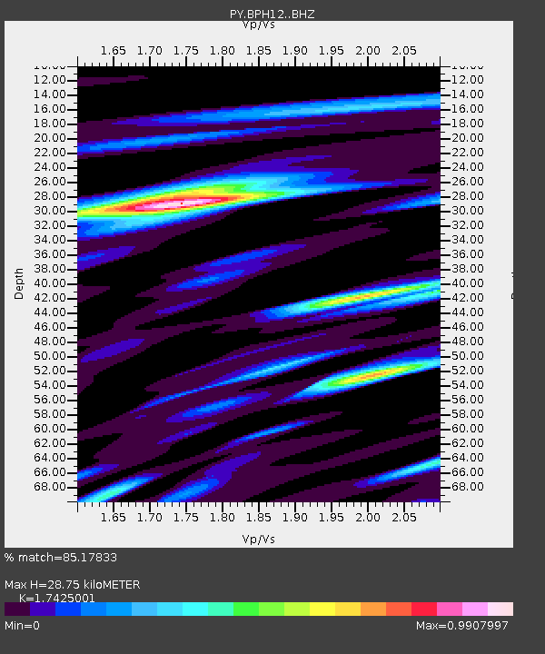
| Estimated Moho Depth: |
28.75 km |
| Estimated Crust Vp/Vs: |
1.74 |
| Assumed Crust Vp: |
6.264 km/s |
| Estimated Crust Vs: |
3.595 km/s |
| Estimated Crust Poisson's Ratio: |
0.25 |
|
| Radial Match: |
85.17833 % |
| Radial Bump: |
400 |
| Transverse Match: |
67.413315 % |
| Transverse Bump: |
400 |
| SOD ConfigId: |
3390531 |
| Insert Time: |
2019-04-11 14:59:10.501 +0000 |
| GWidth: |
2.5 |
| Max Bumps: |
400 |
| Tol: |
0.001 |
|

Signal To Noise
| Channel | StoN | STA | LTA |
| PY:BPH12: :BHZ:20140426T06:13:40.225012Z | 8.132219 | 2.685911E-6 | 3.3028022E-7 |
| PY:BPH12: :BHN:20140426T06:13:40.225012Z | 2.3999722 | 6.173203E-7 | 2.5721977E-7 |
| PY:BPH12: :BHE:20140426T06:13:40.225012Z | 4.489134 | 7.782787E-7 | 1.7336946E-7 |
| Arrivals |
| Ps | 3.5 SECOND |
| PpPs | 12 SECOND |
| PsPs/PpSs | 16 SECOND |


