You are here: Home > Network List > TA - USArray Transportable Network (new EarthScope stations) Stations List
> Station C06D Leavenworth, WQ, USA > Earthquake Result Viewer
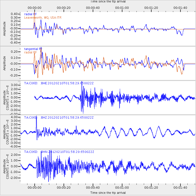
C06D Leavenworth, WQ, USA - Earthquake Result Viewer
*The percent match for this event was below the threshold and hence no stack was calculated.
| Earthquake location: |
Fiji Islands Region |
| Earthquake latitude/longitude: |
-18.0/-178.5 |
| Earthquake time(UTC): |
2012/02/10 (041) 01:47:34 GMT |
| Earthquake Depth: |
582 km |
| Earthquake Magnitude: |
6.0 MB, 5.9 MW, 6.0 MW |
| Earthquake Catalog/Contributor: |
WHDF/NEIC |
|
| Network: |
TA USArray Transportable Network (new EarthScope stations) |
| Station: |
C06D Leavenworth, WQ, USA |
| Lat/Lon: |
47.92 N/120.89 W |
| Elevation: |
544 m |
|
| Distance: |
83.4 deg |
| Az: |
34.896 deg |
| Baz: |
234.055 deg |
| Ray Param: |
$rayparam |
*The percent match for this event was below the threshold and hence was not used in the summary stack. |
|
| Radial Match: |
52.703674 % |
| Radial Bump: |
400 |
| Transverse Match: |
49.78039 % |
| Transverse Bump: |
400 |
| SOD ConfigId: |
436445 |
| Insert Time: |
2012-04-21 06:23:40.745 +0000 |
| GWidth: |
2.5 |
| Max Bumps: |
400 |
| Tol: |
0.001 |
|
Signal To Noise
| Channel | StoN | STA | LTA |
| TA:C06D: :BHZ:20120210T01:58:29.650022Z | 3.0791047 | 1.1431717E-6 | 3.712676E-7 |
| TA:C06D: :BHN:20120210T01:58:29.650022Z | 2.9253304 | 9.1607086E-7 | 3.1315128E-7 |
| TA:C06D: :BHE:20120210T01:58:29.650022Z | 5.398709 | 1.3914275E-6 | 2.577334E-7 |
| Arrivals |
| Ps | |
| PpPs | |
| PsPs/PpSs | |


