You are here: Home > Network List > UW - Pacific Northwest Regional Seismic Network Stations List
> Station IZEE Izee, OR, USA > Earthquake Result Viewer
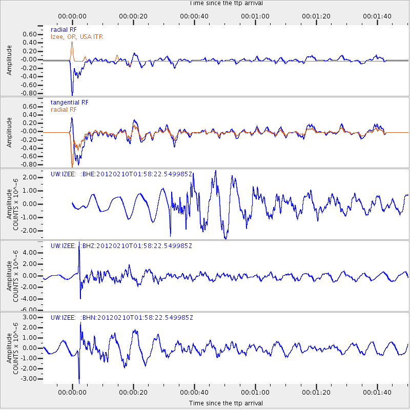
IZEE Izee, OR, USA - Earthquake Result Viewer
*The percent match for this event was below the threshold and hence no stack was calculated.
| Earthquake location: |
Fiji Islands Region |
| Earthquake latitude/longitude: |
-18.0/-178.5 |
| Earthquake time(UTC): |
2012/02/10 (041) 01:47:34 GMT |
| Earthquake Depth: |
582 km |
| Earthquake Magnitude: |
6.0 MB, 5.9 MW, 6.0 MW |
| Earthquake Catalog/Contributor: |
WHDF/NEIC |
|
| Network: |
UW Pacific Northwest Regional Seismic Network |
| Station: |
IZEE Izee, OR, USA |
| Lat/Lon: |
44.08 N/119.50 W |
| Elevation: |
1293 m |
|
| Distance: |
81.9 deg |
| Az: |
38.624 deg |
| Baz: |
235.529 deg |
| Ray Param: |
$rayparam |
*The percent match for this event was below the threshold and hence was not used in the summary stack. |
|
| Radial Match: |
82.654755 % |
| Radial Bump: |
400 |
| Transverse Match: |
77.60222 % |
| Transverse Bump: |
400 |
| SOD ConfigId: |
436445 |
| Insert Time: |
2012-04-21 06:27:38.157 +0000 |
| GWidth: |
2.5 |
| Max Bumps: |
400 |
| Tol: |
0.001 |
|
Signal To Noise
| Channel | StoN | STA | LTA |
| UW:IZEE: :BHZ:20120210T01:58:22.549985Z | 4.180689 | 1.5699351E-6 | 3.755207E-7 |
| UW:IZEE: :BHN:20120210T01:58:22.549985Z | 3.5838451 | 1.03785E-6 | 2.8959118E-7 |
| UW:IZEE: :BHE:20120210T01:58:22.549985Z | 1.6379802 | 7.986252E-7 | 4.8756704E-7 |
| Arrivals |
| Ps | |
| PpPs | |
| PsPs/PpSs | |


