You are here: Home > Network List > TA - USArray Transportable Network (new EarthScope stations) Stations List
> Station 121A Cookes Peak, Deming, NM, USA > Earthquake Result Viewer
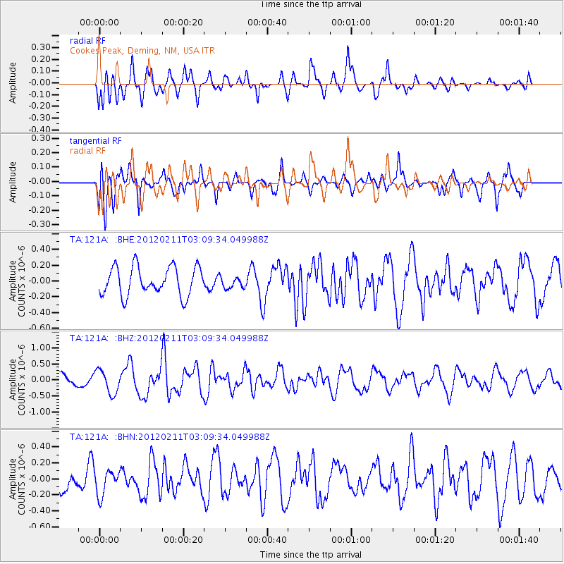
121A Cookes Peak, Deming, NM, USA - Earthquake Result Viewer
*The percent match for this event was below the threshold and hence no stack was calculated.
| Earthquake location: |
Near Coast Of Central Chile |
| Earthquake latitude/longitude: |
-37.5/-73.9 |
| Earthquake time(UTC): |
2012/02/11 (042) 02:58:17 GMT |
| Earthquake Depth: |
20 km |
| Earthquake Magnitude: |
5.6 MB, 5.3 MS, 5.6 MW, 5.7 MW |
| Earthquake Catalog/Contributor: |
WHDF/NEIC |
|
| Network: |
TA USArray Transportable Network (new EarthScope stations) |
| Station: |
121A Cookes Peak, Deming, NM, USA |
| Lat/Lon: |
32.53 N/107.79 W |
| Elevation: |
1652 m |
|
| Distance: |
76.5 deg |
| Az: |
331.015 deg |
| Baz: |
152.838 deg |
| Ray Param: |
$rayparam |
*The percent match for this event was below the threshold and hence was not used in the summary stack. |
|
| Radial Match: |
60.65708 % |
| Radial Bump: |
400 |
| Transverse Match: |
65.546165 % |
| Transverse Bump: |
398 |
| SOD ConfigId: |
436445 |
| Insert Time: |
2012-04-21 06:45:39.097 +0000 |
| GWidth: |
2.5 |
| Max Bumps: |
400 |
| Tol: |
0.001 |
|
Signal To Noise
| Channel | StoN | STA | LTA |
| TA:121A: :BHZ:20120211T03:09:34.049988Z | 2.1645596 | 3.7492276E-7 | 1.7320971E-7 |
| TA:121A: :BHN:20120211T03:09:34.049988Z | 0.8007391 | 1.6122202E-7 | 2.013415E-7 |
| TA:121A: :BHE:20120211T03:09:34.049988Z | 0.3953171 | 7.157498E-8 | 1.8105713E-7 |
| Arrivals |
| Ps | |
| PpPs | |
| PsPs/PpSs | |


