You are here: Home > Network List > TA - USArray Transportable Network (new EarthScope stations) Stations List
> Station T47A Sharon Grove, KY, USA > Earthquake Result Viewer
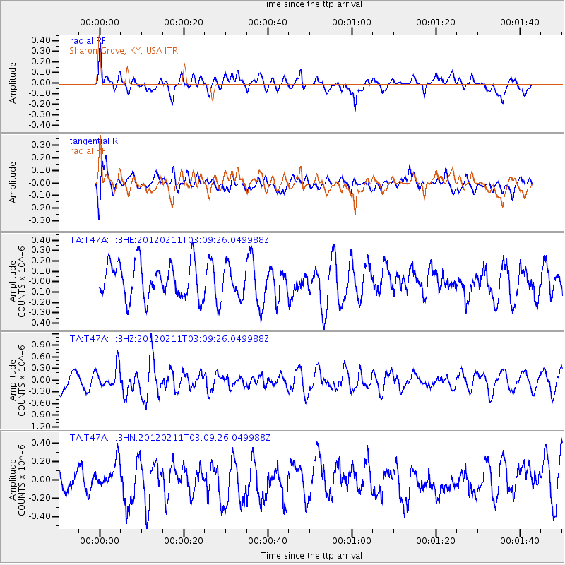
T47A Sharon Grove, KY, USA - Earthquake Result Viewer
*The percent match for this event was below the threshold and hence no stack was calculated.
| Earthquake location: |
Near Coast Of Central Chile |
| Earthquake latitude/longitude: |
-37.5/-73.9 |
| Earthquake time(UTC): |
2012/02/11 (042) 02:58:17 GMT |
| Earthquake Depth: |
20 km |
| Earthquake Magnitude: |
5.6 MB, 5.3 MS, 5.6 MW, 5.7 MW |
| Earthquake Catalog/Contributor: |
WHDF/NEIC |
|
| Network: |
TA USArray Transportable Network (new EarthScope stations) |
| Station: |
T47A Sharon Grove, KY, USA |
| Lat/Lon: |
36.99 N/87.11 W |
| Elevation: |
217 m |
|
| Distance: |
75.1 deg |
| Az: |
349.075 deg |
| Baz: |
169.143 deg |
| Ray Param: |
$rayparam |
*The percent match for this event was below the threshold and hence was not used in the summary stack. |
|
| Radial Match: |
53.63054 % |
| Radial Bump: |
400 |
| Transverse Match: |
54.32247 % |
| Transverse Bump: |
400 |
| SOD ConfigId: |
436445 |
| Insert Time: |
2012-04-21 06:53:50.894 +0000 |
| GWidth: |
2.5 |
| Max Bumps: |
400 |
| Tol: |
0.001 |
|
Signal To Noise
| Channel | StoN | STA | LTA |
| TA:T47A: :BHZ:20120211T03:09:26.049988Z | 1.3256602 | 2.8417418E-7 | 2.1436425E-7 |
| TA:T47A: :BHN:20120211T03:09:26.049988Z | 1.250845 | 1.5581057E-7 | 1.2456427E-7 |
| TA:T47A: :BHE:20120211T03:09:26.049988Z | 0.84166074 | 1.4159679E-7 | 1.6823499E-7 |
| Arrivals |
| Ps | |
| PpPs | |
| PsPs/PpSs | |


