You are here: Home > Network List > G - GEOSCOPE Stations List
> Station HYB Hyderabad, India > Earthquake Result Viewer
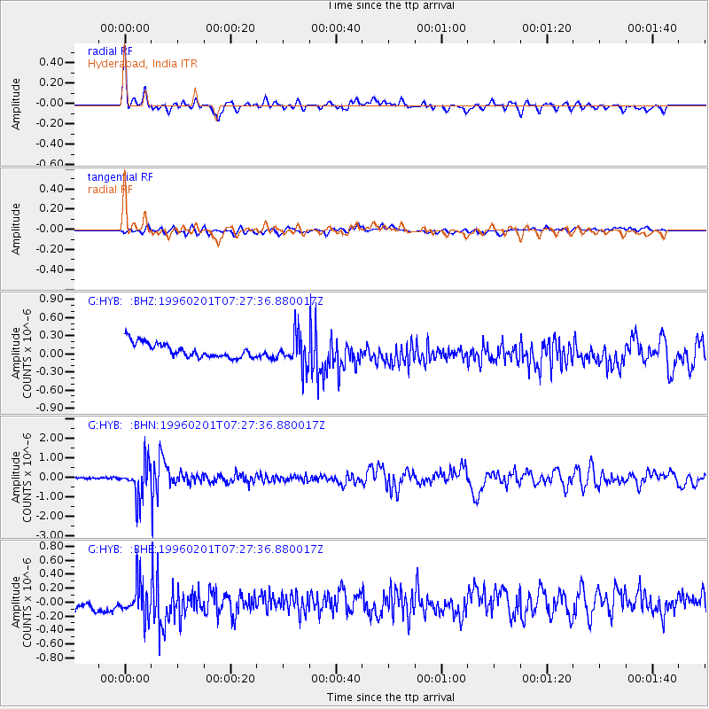
HYB Hyderabad, India - Earthquake Result Viewer
*The percent match for this event was below the threshold and hence no stack was calculated.
| Earthquake location: |
Kuril Islands |
| Earthquake latitude/longitude: |
44.9/146.3 |
| Earthquake time(UTC): |
1996/02/01 (032) 07:18:05 GMT |
| Earthquake Depth: |
180 km |
| Earthquake Magnitude: |
5.7 MB, 6.2 UNKNOWN, 6.2 MW |
| Earthquake Catalog/Contributor: |
WHDF/NEIC |
|
| Network: |
G GEOSCOPE |
| Station: |
HYB Hyderabad, India |
| Lat/Lon: |
17.42 N/78.55 E |
| Elevation: |
510 m |
|
| Distance: |
62.2 deg |
| Az: |
267.234 deg |
| Baz: |
48.075 deg |
| Ray Param: |
$rayparam |
*The percent match for this event was below the threshold and hence was not used in the summary stack. |
|
| Radial Match: |
67.03463 % |
| Radial Bump: |
400 |
| Transverse Match: |
56.3644 % |
| Transverse Bump: |
400 |
| SOD ConfigId: |
4480 |
| Insert Time: |
2010-02-26 23:10:37.463 +0000 |
| GWidth: |
2.5 |
| Max Bumps: |
400 |
| Tol: |
0.001 |
|
Signal To Noise
| Channel | StoN | STA | LTA |
| G:HYB: :BHN:19960201T07:27:36.880017Z | 14.728286 | 9.045366E-7 | 6.141492E-8 |
| G:HYB: :BHE:19960201T07:27:36.880017Z | 1.8748122 | 2.5727607E-7 | 1.3722764E-7 |
| G:HYB: :BHZ:19960201T07:27:36.880017Z | 2.2412047 | 2.6498546E-7 | 1.1823349E-7 |
| Arrivals |
| Ps | |
| PpPs | |
| PsPs/PpSs | |


