You are here: Home > Network List > CI - Caltech Regional Seismic Network Stations List
> Station LGU LGU, Camarillo, CA, USA > Earthquake Result Viewer
LGU LGU, Camarillo, CA, USA - Earthquake Result Viewer
| Earthquake location: |
Vanuatu Islands |
| Earthquake latitude/longitude: |
-13.1/166.5 |
| Earthquake time(UTC): |
2009/10/07 (280) 23:13:48 GMT |
| Earthquake Depth: |
31 km |
| Earthquake Magnitude: |
6.4 MB, 7.2 MS, 7.4 MW, 7.4 MW |
| Earthquake Catalog/Contributor: |
WHDF/NEIC |
|
| Network: |
CI Caltech Regional Seismic Network |
| Station: |
LGU LGU, Camarillo, CA, USA |
| Lat/Lon: |
34.11 N/119.07 W |
| Elevation: |
416 m |
|
| Distance: |
84.8 deg |
| Az: |
53.384 deg |
| Baz: |
250.484 deg |
| Ray Param: |
0.045208827 |
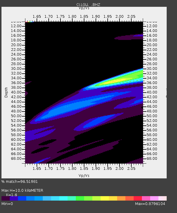
| Estimated Moho Depth: |
10.0 km |
| Estimated Crust Vp/Vs: |
1.60 |
| Assumed Crust Vp: |
6.1 km/s |
| Estimated Crust Vs: |
3.812 km/s |
| Estimated Crust Poisson's Ratio: |
0.18 |
|
| Radial Match: |
96.51981 % |
| Radial Bump: |
400 |
| Transverse Match: |
96.49305 % |
| Transverse Bump: |
155 |
| SOD ConfigId: |
2622 |
| Insert Time: |
2010-02-25 20:20:34.974 +0000 |
| GWidth: |
2.5 |
| Max Bumps: |
400 |
| Tol: |
0.001 |
|
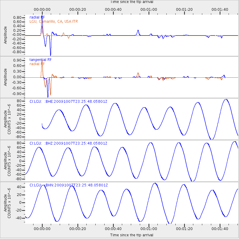
Signal To Noise
| Channel | StoN | STA | LTA |
| CI:LGU: :BHZ:20091007T23:25:48.05801Z | 1.2574644 | 4.0370775E-5 | 3.2104905E-5 |
| CI:LGU: :BHN:20091007T23:25:48.05801Z | 2.0344386 | 4.009238E-5 | 1.970685E-5 |
| CI:LGU: :BHE:20091007T23:25:48.05801Z | 1.6023911 | 5.8524398E-5 | 3.6523168E-5 |
| Arrivals |
| Ps | 1.0 SECOND |
| PpPs | 4.2 SECOND |
| PsPs/PpSs | 5.2 SECOND |


