You are here: Home > Network List > G - GEOSCOPE Stations List
> Station HYB Hyderabad, India > Earthquake Result Viewer
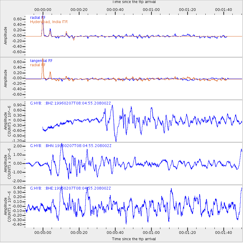
HYB Hyderabad, India - Earthquake Result Viewer
*The percent match for this event was below the threshold and hence no stack was calculated.
| Earthquake location: |
Minahassa Peninsula, Sulawesi |
| Earthquake latitude/longitude: |
1.0/120.2 |
| Earthquake time(UTC): |
1996/02/07 (038) 07:57:20 GMT |
| Earthquake Depth: |
33 km |
| Earthquake Magnitude: |
5.5 MB, 5.6 MS, 6.1 UNKNOWN, 5.9 MW |
| Earthquake Catalog/Contributor: |
WHDF/NEIC |
|
| Network: |
G GEOSCOPE |
| Station: |
HYB Hyderabad, India |
| Lat/Lon: |
17.42 N/78.55 E |
| Elevation: |
510 m |
|
| Distance: |
44.1 deg |
| Az: |
294.211 deg |
| Baz: |
107.223 deg |
| Ray Param: |
$rayparam |
*The percent match for this event was below the threshold and hence was not used in the summary stack. |
|
| Radial Match: |
77.94168 % |
| Radial Bump: |
275 |
| Transverse Match: |
50.965775 % |
| Transverse Bump: |
400 |
| SOD ConfigId: |
4480 |
| Insert Time: |
2010-02-26 23:10:41.436 +0000 |
| GWidth: |
2.5 |
| Max Bumps: |
400 |
| Tol: |
0.001 |
|
Signal To Noise
| Channel | StoN | STA | LTA |
| G:HYB: :BHN:19960207T08:04:55.208002Z | 4.538164 | 3.8735172E-7 | 8.535427E-8 |
| G:HYB: :BHE:19960207T08:04:55.208002Z | 0.96865696 | 5.089661E-8 | 5.254348E-8 |
| G:HYB: :BHZ:19960207T08:04:55.208002Z | 1.8635706 | 3.698277E-7 | 1.9845113E-7 |
| Arrivals |
| Ps | |
| PpPs | |
| PsPs/PpSs | |


