You are here: Home > Network List > G - GEOSCOPE Stations List
> Station HYB Hyderabad, India > Earthquake Result Viewer
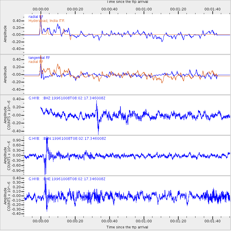
HYB Hyderabad, India - Earthquake Result Viewer
*The percent match for this event was below the threshold and hence no stack was calculated.
| Earthquake location: |
Northwest Of Kuril Islands |
| Earthquake latitude/longitude: |
52.9/152.5 |
| Earthquake time(UTC): |
1996/10/08 (282) 07:52:58 GMT |
| Earthquake Depth: |
627 km |
| Earthquake Magnitude: |
5.6 UNKNOWN, 5.2 MB |
| Earthquake Catalog/Contributor: |
WHDF/NEIC |
|
| Network: |
G GEOSCOPE |
| Station: |
HYB Hyderabad, India |
| Lat/Lon: |
17.42 N/78.55 E |
| Elevation: |
510 m |
|
| Distance: |
66.7 deg |
| Az: |
268.177 deg |
| Baz: |
39.389 deg |
| Ray Param: |
$rayparam |
*The percent match for this event was below the threshold and hence was not used in the summary stack. |
|
| Radial Match: |
44.359013 % |
| Radial Bump: |
400 |
| Transverse Match: |
63.30465 % |
| Transverse Bump: |
400 |
| SOD ConfigId: |
4480 |
| Insert Time: |
2010-02-26 23:10:42.940 +0000 |
| GWidth: |
2.5 |
| Max Bumps: |
400 |
| Tol: |
0.001 |
|
Signal To Noise
| Channel | StoN | STA | LTA |
| G:HYB: :BHN:19961008T08:02:17.346008Z | 6.633681 | 4.1646248E-7 | 6.278E-8 |
| G:HYB: :BHE:19961008T08:02:17.346008Z | 1.7046635 | 1.4541205E-7 | 8.530249E-8 |
| G:HYB: :BHZ:19961008T08:02:17.346008Z | 2.1429133 | 1.5117341E-7 | 7.054574E-8 |
| Arrivals |
| Ps | |
| PpPs | |
| PsPs/PpSs | |


