You are here: Home > Network List > YT07 - POLENET Stations List
> Station UNGL UNGL > Earthquake Result Viewer
UNGL UNGL - Earthquake Result Viewer
| Earthquake location: |
Tonga Islands |
| Earthquake latitude/longitude: |
-20.7/-174.7 |
| Earthquake time(UTC): |
2014/04/26 (116) 06:02:16 GMT |
| Earthquake Depth: |
10 km |
| Earthquake Magnitude: |
6.5 MWP |
| Earthquake Catalog/Contributor: |
NEIC PDE/NEIC COMCAT |
|
| Network: |
YT POLENET |
| Station: |
UNGL UNGL |
| Lat/Lon: |
79.77 S/82.52 W |
| Elevation: |
745 m |
|
| Distance: |
70.1 deg |
| Az: |
169.056 deg |
| Baz: |
264.057 deg |
| Ray Param: |
0.055181682 |
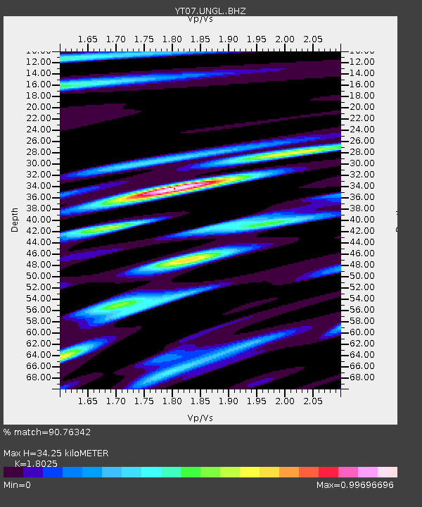
| Estimated Moho Depth: |
34.25 km |
| Estimated Crust Vp/Vs: |
1.80 |
| Assumed Crust Vp: |
6.182 km/s |
| Estimated Crust Vs: |
3.429 km/s |
| Estimated Crust Poisson's Ratio: |
0.28 |
|
| Radial Match: |
90.76342 % |
| Radial Bump: |
400 |
| Transverse Match: |
70.52158 % |
| Transverse Bump: |
400 |
| SOD ConfigId: |
3390531 |
| Insert Time: |
2019-04-11 15:01:10.054 +0000 |
| GWidth: |
2.5 |
| Max Bumps: |
400 |
| Tol: |
0.001 |
|

Signal To Noise
| Channel | StoN | STA | LTA |
| YT:UNGL: :BHZ:20140426T06:12:57.598975Z | 10.254516 | 1.9415436E-6 | 1.8933547E-7 |
| YT:UNGL: :BHN:20140426T06:12:57.598975Z | 1.470552 | 1.2328242E-7 | 8.383411E-8 |
| YT:UNGL: :BHE:20140426T06:12:57.598975Z | 6.085256 | 7.8603296E-7 | 1.2917008E-7 |
| Arrivals |
| Ps | 4.6 SECOND |
| PpPs | 15 SECOND |
| PsPs/PpSs | 20 SECOND |


