You are here: Home > Network List > CI - Caltech Regional Seismic Network Stations List
> Station MPM Manuel Prospect Mine, California, USA > Earthquake Result Viewer
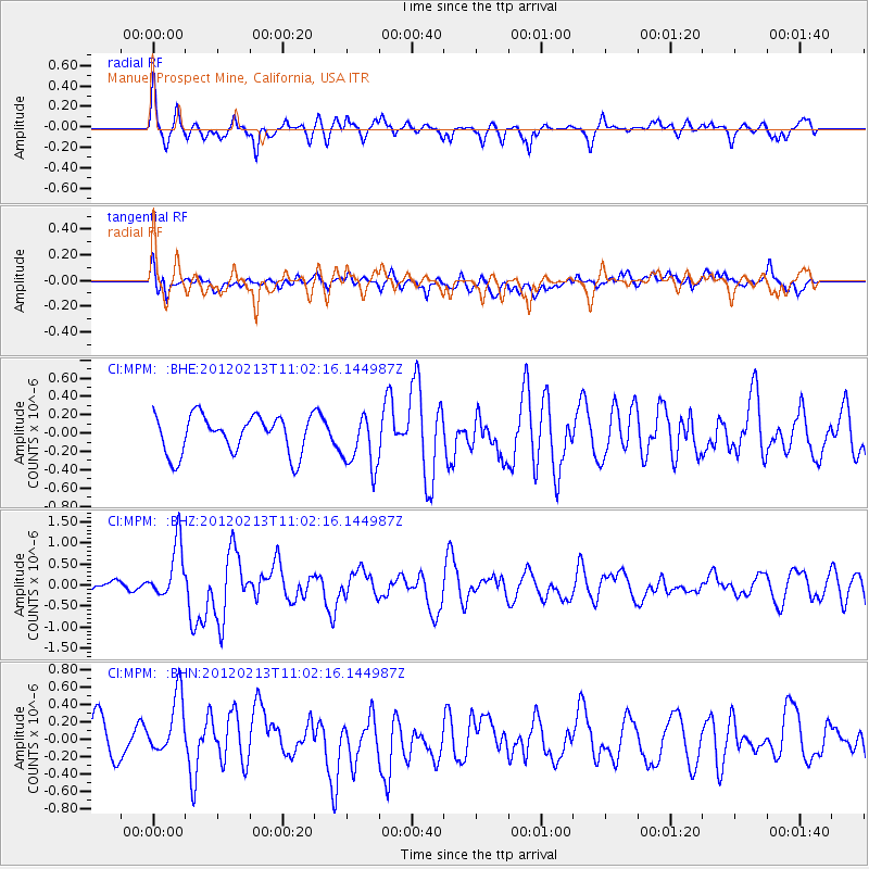
MPM Manuel Prospect Mine, California, USA - Earthquake Result Viewer
*The percent match for this event was below the threshold and hence no stack was calculated.
| Earthquake location: |
Costa Rica |
| Earthquake latitude/longitude: |
9.2/-84.1 |
| Earthquake time(UTC): |
2012/02/13 (044) 10:55:09 GMT |
| Earthquake Depth: |
16 km |
| Earthquake Magnitude: |
5.6 MB, 5.5 MS, 5.9 MW, 5.7 MW |
| Earthquake Catalog/Contributor: |
WHDF/NEIC |
|
| Network: |
CI Caltech Regional Seismic Network |
| Station: |
MPM Manuel Prospect Mine, California, USA |
| Lat/Lon: |
36.06 N/117.49 W |
| Elevation: |
185 m |
|
| Distance: |
40.4 deg |
| Az: |
316.602 deg |
| Baz: |
123.155 deg |
| Ray Param: |
$rayparam |
*The percent match for this event was below the threshold and hence was not used in the summary stack. |
|
| Radial Match: |
70.15043 % |
| Radial Bump: |
397 |
| Transverse Match: |
53.51111 % |
| Transverse Bump: |
400 |
| SOD ConfigId: |
439822 |
| Insert Time: |
2012-04-27 07:59:04.925 +0000 |
| GWidth: |
2.5 |
| Max Bumps: |
400 |
| Tol: |
0.001 |
|
Signal To Noise
| Channel | StoN | STA | LTA |
| CI:MPM: :BHZ:20120213T11:02:16.144987Z | 2.1141016 | 6.55803E-7 | 3.102041E-7 |
| CI:MPM: :BHN:20120213T11:02:16.144987Z | 1.576705 | 4.0681317E-7 | 2.5801475E-7 |
| CI:MPM: :BHE:20120213T11:02:16.144987Z | 1.4126446 | 2.9512236E-7 | 2.0891478E-7 |
| Arrivals |
| Ps | |
| PpPs | |
| PsPs/PpSs | |


