You are here: Home > Network List > GS - US Geological Survey Networks Stations List
> Station DEC09 Decatur Surface Seismic Site, Decatur, IL, USA > Earthquake Result Viewer
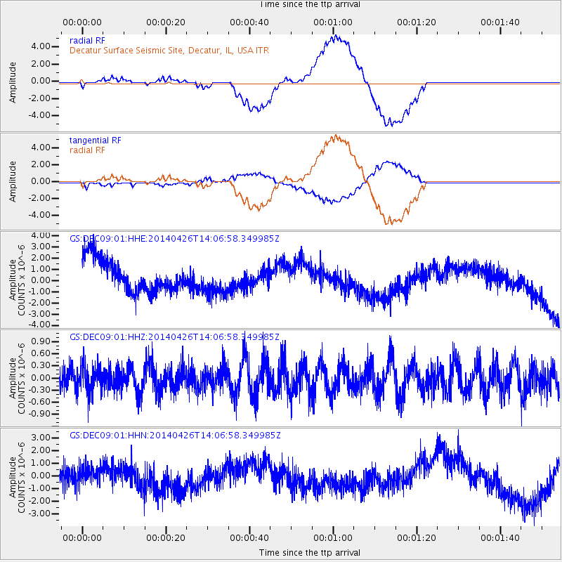
DEC09 Decatur Surface Seismic Site, Decatur, IL, USA - Earthquake Result Viewer
*The percent match for this event was below the threshold and hence no stack was calculated.
| Earthquake location: |
Kuril Islands |
| Earthquake latitude/longitude: |
48.5/153.3 |
| Earthquake time(UTC): |
2014/04/26 (116) 13:55:55 GMT |
| Earthquake Depth: |
131 km |
| Earthquake Magnitude: |
5.1 MW |
| Earthquake Catalog/Contributor: |
ISC/ISC |
|
| Network: |
GS US Geological Survey Networks |
| Station: |
DEC09 Decatur Surface Seismic Site, Decatur, IL, USA |
| Lat/Lon: |
39.87 N/88.92 W |
| Elevation: |
207 m |
|
| Distance: |
76.2 deg |
| Az: |
44.52 deg |
| Baz: |
322.662 deg |
| Ray Param: |
$rayparam |
*The percent match for this event was below the threshold and hence was not used in the summary stack. |
|
| Radial Match: |
63.408276 % |
| Radial Bump: |
400 |
| Transverse Match: |
63.456684 % |
| Transverse Bump: |
400 |
| SOD ConfigId: |
3390531 |
| Insert Time: |
2019-04-11 15:04:25.749 +0000 |
| GWidth: |
2.5 |
| Max Bumps: |
400 |
| Tol: |
0.001 |
|
Signal To Noise
| Channel | StoN | STA | LTA |
| GS:DEC09:01:HHZ:20140426T14:06:58.349985Z | 1.0675752 | 3.3119898E-7 | 3.102348E-7 |
| GS:DEC09:01:HHN:20140426T14:06:58.349985Z | 0.6610402 | 7.376326E-7 | 1.1158664E-6 |
| GS:DEC09:01:HHE:20140426T14:06:58.349985Z | 1.0004714 | 1.3946412E-6 | 1.3939841E-6 |
| Arrivals |
| Ps | |
| PpPs | |
| PsPs/PpSs | |


