You are here: Home > Network List > IU - Global Seismograph Network (GSN - IRIS/USGS) Stations List
> Station PMG Port Moresby, New Guinea > Earthquake Result Viewer
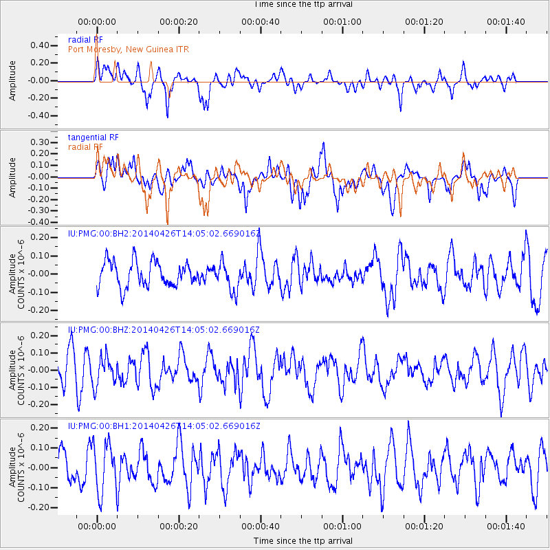
PMG Port Moresby, New Guinea - Earthquake Result Viewer
*The percent match for this event was below the threshold and hence no stack was calculated.
| Earthquake location: |
Kuril Islands |
| Earthquake latitude/longitude: |
48.5/153.3 |
| Earthquake time(UTC): |
2014/04/26 (116) 13:55:55 GMT |
| Earthquake Depth: |
131 km |
| Earthquake Magnitude: |
5.1 MW |
| Earthquake Catalog/Contributor: |
ISC/ISC |
|
| Network: |
IU Global Seismograph Network (GSN - IRIS/USGS) |
| Station: |
PMG Port Moresby, New Guinea |
| Lat/Lon: |
9.40 S/147.16 E |
| Elevation: |
90 m |
|
| Distance: |
57.9 deg |
| Az: |
187.185 deg |
| Baz: |
4.84 deg |
| Ray Param: |
$rayparam |
*The percent match for this event was below the threshold and hence was not used in the summary stack. |
|
| Radial Match: |
68.12652 % |
| Radial Bump: |
400 |
| Transverse Match: |
57.268436 % |
| Transverse Bump: |
400 |
| SOD ConfigId: |
3390531 |
| Insert Time: |
2019-04-11 15:04:52.060 +0000 |
| GWidth: |
2.5 |
| Max Bumps: |
400 |
| Tol: |
0.001 |
|
Signal To Noise
| Channel | StoN | STA | LTA |
| IU:PMG:00:BHZ:20140426T14:05:02.669016Z | 0.78645337 | 8.224368E-8 | 1.04575406E-7 |
| IU:PMG:00:BH1:20140426T14:05:02.669016Z | 1.7188016 | 1.2495497E-7 | 7.269889E-8 |
| IU:PMG:00:BH2:20140426T14:05:02.669016Z | 1.1842043 | 8.0909864E-8 | 6.832424E-8 |
| Arrivals |
| Ps | |
| PpPs | |
| PsPs/PpSs | |


