You are here: Home > Network List > TA - USArray Transportable Network (new EarthScope stations) Stations List
> Station O33A Hebron, NE, USA > Earthquake Result Viewer
O33A Hebron, NE, USA - Earthquake Result Viewer
| Earthquake location: |
Costa Rica |
| Earthquake latitude/longitude: |
9.2/-84.1 |
| Earthquake time(UTC): |
2012/02/13 (044) 10:55:09 GMT |
| Earthquake Depth: |
16 km |
| Earthquake Magnitude: |
5.6 MB, 5.5 MS, 5.9 MW, 5.7 MW |
| Earthquake Catalog/Contributor: |
WHDF/NEIC |
|
| Network: |
TA USArray Transportable Network (new EarthScope stations) |
| Station: |
O33A Hebron, NE, USA |
| Lat/Lon: |
40.08 N/97.58 W |
| Elevation: |
480 m |
|
| Distance: |
33.0 deg |
| Az: |
340.863 deg |
| Baz: |
155.049 deg |
| Ray Param: |
0.078387395 |
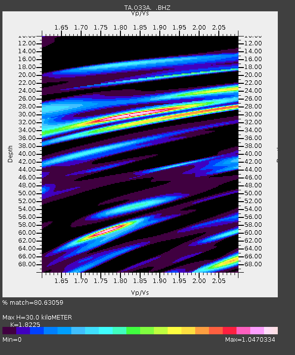
| Estimated Moho Depth: |
30.0 km |
| Estimated Crust Vp/Vs: |
1.82 |
| Assumed Crust Vp: |
6.498 km/s |
| Estimated Crust Vs: |
3.565 km/s |
| Estimated Crust Poisson's Ratio: |
0.28 |
|
| Radial Match: |
80.63059 % |
| Radial Bump: |
295 |
| Transverse Match: |
62.01719 % |
| Transverse Bump: |
400 |
| SOD ConfigId: |
439822 |
| Insert Time: |
2012-04-27 08:08:40.077 +0000 |
| GWidth: |
2.5 |
| Max Bumps: |
400 |
| Tol: |
0.001 |
|
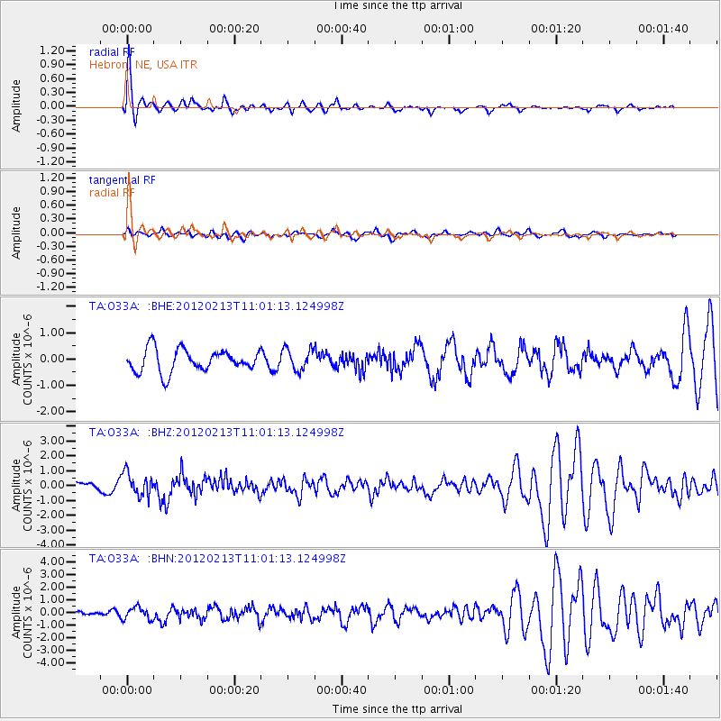
Signal To Noise
| Channel | StoN | STA | LTA |
| TA:O33A: :BHZ:20120213T11:01:13.124998Z | 1.6910658 | 7.7908356E-7 | 4.6070565E-7 |
| TA:O33A: :BHN:20120213T11:01:13.124998Z | 2.0717556 | 4.801666E-7 | 2.3176796E-7 |
| TA:O33A: :BHE:20120213T11:01:13.124998Z | 0.9653369 | 4.124756E-7 | 4.272867E-7 |
| Arrivals |
| Ps | 4.1 SECOND |
| PpPs | 12 SECOND |
| PsPs/PpSs | 16 SECOND |


