You are here: Home > Network List > TA - USArray Transportable Network (new EarthScope stations) Stations List
> Station M33A Taylor Creek Farms, Clarkson, NE, USA > Earthquake Result Viewer
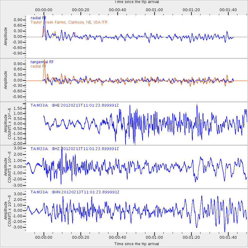
M33A Taylor Creek Farms, Clarkson, NE, USA - Earthquake Result Viewer
*The percent match for this event was below the threshold and hence no stack was calculated.
| Earthquake location: |
Costa Rica |
| Earthquake latitude/longitude: |
9.2/-84.1 |
| Earthquake time(UTC): |
2012/02/13 (044) 10:55:09 GMT |
| Earthquake Depth: |
16 km |
| Earthquake Magnitude: |
5.6 MB, 5.5 MS, 5.9 MW, 5.7 MW |
| Earthquake Catalog/Contributor: |
WHDF/NEIC |
|
| Network: |
TA USArray Transportable Network (new EarthScope stations) |
| Station: |
M33A Taylor Creek Farms, Clarkson, NE, USA |
| Lat/Lon: |
41.57 N/97.19 W |
| Elevation: |
503 m |
|
| Distance: |
34.3 deg |
| Az: |
342.455 deg |
| Baz: |
156.628 deg |
| Ray Param: |
$rayparam |
*The percent match for this event was below the threshold and hence was not used in the summary stack. |
|
| Radial Match: |
69.82039 % |
| Radial Bump: |
400 |
| Transverse Match: |
55.58497 % |
| Transverse Bump: |
400 |
| SOD ConfigId: |
439822 |
| Insert Time: |
2012-04-27 08:08:54.045 +0000 |
| GWidth: |
2.5 |
| Max Bumps: |
400 |
| Tol: |
0.001 |
|
Signal To Noise
| Channel | StoN | STA | LTA |
| TA:M33A: :BHZ:20120213T11:01:23.899991Z | 2.831456 | 8.723543E-7 | 3.080939E-7 |
| TA:M33A: :BHN:20120213T11:01:23.899991Z | 1.8685081 | 8.131441E-7 | 4.3518358E-7 |
| TA:M33A: :BHE:20120213T11:01:23.899991Z | 1.3427125 | 4.1232016E-7 | 3.0708E-7 |
| Arrivals |
| Ps | |
| PpPs | |
| PsPs/PpSs | |


