You are here: Home > Network List > KN - Kyrgyz Seismic Telemetry Network Stations List
> Station TKM2 - > Earthquake Result Viewer
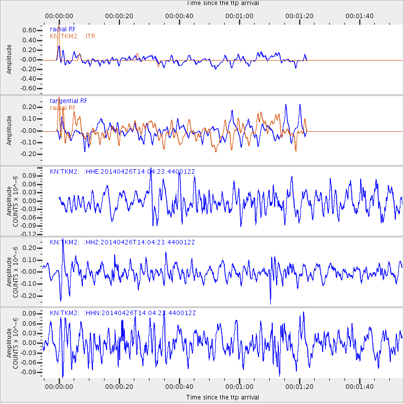
TKM2 - - Earthquake Result Viewer
*The percent match for this event was below the threshold and hence no stack was calculated.
| Earthquake location: |
Kuril Islands |
| Earthquake latitude/longitude: |
48.5/153.3 |
| Earthquake time(UTC): |
2014/04/26 (116) 13:55:55 GMT |
| Earthquake Depth: |
131 km |
| Earthquake Magnitude: |
5.1 MW |
| Earthquake Catalog/Contributor: |
ISC/ISC |
|
| Network: |
KN Kyrgyz Seismic Telemetry Network |
| Station: |
TKM2 - |
| Lat/Lon: |
42.92 N/75.60 E |
| Elevation: |
2020 m |
|
| Distance: |
52.4 deg |
| Az: |
295.029 deg |
| Baz: |
55.198 deg |
| Ray Param: |
$rayparam |
*The percent match for this event was below the threshold and hence was not used in the summary stack. |
|
| Radial Match: |
53.558414 % |
| Radial Bump: |
400 |
| Transverse Match: |
58.00487 % |
| Transverse Bump: |
400 |
| SOD ConfigId: |
3390531 |
| Insert Time: |
2019-04-11 15:05:01.542 +0000 |
| GWidth: |
2.5 |
| Max Bumps: |
400 |
| Tol: |
0.001 |
|
Signal To Noise
| Channel | StoN | STA | LTA |
| KN:TKM2: :HHZ:20140426T14:04:23.440012Z | 2.7886753 | 1.1273123E-7 | 4.042465E-8 |
| KN:TKM2: :HHN:20140426T14:04:23.440012Z | 1.4422054 | 5.2180432E-8 | 3.6181E-8 |
| KN:TKM2: :HHE:20140426T14:04:23.440012Z | 2.2071044 | 5.7544757E-8 | 2.6072511E-8 |
| Arrivals |
| Ps | |
| PpPs | |
| PsPs/PpSs | |


