You are here: Home > Network List > TA - USArray Transportable Network (new EarthScope stations) Stations List
> Station K31A O'Neill, NE, USA > Earthquake Result Viewer
K31A O'Neill, NE, USA - Earthquake Result Viewer
| Earthquake location: |
Costa Rica |
| Earthquake latitude/longitude: |
9.2/-84.1 |
| Earthquake time(UTC): |
2012/02/13 (044) 10:55:09 GMT |
| Earthquake Depth: |
16 km |
| Earthquake Magnitude: |
5.6 MB, 5.5 MS, 5.9 MW, 5.7 MW |
| Earthquake Catalog/Contributor: |
WHDF/NEIC |
|
| Network: |
TA USArray Transportable Network (new EarthScope stations) |
| Station: |
K31A O'Neill, NE, USA |
| Lat/Lon: |
42.62 N/98.75 W |
| Elevation: |
580 m |
|
| Distance: |
35.7 deg |
| Az: |
341.364 deg |
| Baz: |
154.693 deg |
| Ray Param: |
0.0770677 |
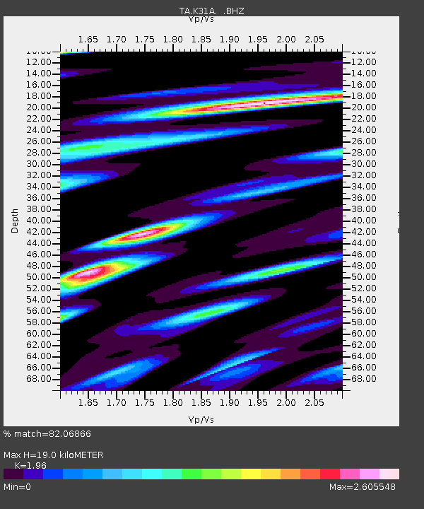
| Estimated Moho Depth: |
19.0 km |
| Estimated Crust Vp/Vs: |
1.96 |
| Assumed Crust Vp: |
6.53 km/s |
| Estimated Crust Vs: |
3.332 km/s |
| Estimated Crust Poisson's Ratio: |
0.32 |
|
| Radial Match: |
82.06866 % |
| Radial Bump: |
371 |
| Transverse Match: |
57.734 % |
| Transverse Bump: |
400 |
| SOD ConfigId: |
439822 |
| Insert Time: |
2012-04-27 08:10:22.278 +0000 |
| GWidth: |
2.5 |
| Max Bumps: |
400 |
| Tol: |
0.001 |
|

Signal To Noise
| Channel | StoN | STA | LTA |
| TA:K31A: :BHZ:20120213T11:01:36.249998Z | 3.3097525 | 8.215725E-7 | 2.4822776E-7 |
| TA:K31A: :BHN:20120213T11:01:36.249998Z | 1.6134335 | 7.9077876E-7 | 4.901217E-7 |
| TA:K31A: :BHE:20120213T11:01:36.249998Z | 1.8346599 | 7.4516663E-7 | 4.0616064E-7 |
| Arrivals |
| Ps | 3.0 SECOND |
| PpPs | 8.0 SECOND |
| PsPs/PpSs | 11 SECOND |


