You are here: Home > Network List > TA - USArray Transportable Network (new EarthScope stations) Stations List
> Station K40A Colesburg, IA, USA > Earthquake Result Viewer
K40A Colesburg, IA, USA - Earthquake Result Viewer
| Earthquake location: |
Costa Rica |
| Earthquake latitude/longitude: |
9.2/-84.1 |
| Earthquake time(UTC): |
2012/02/13 (044) 10:55:09 GMT |
| Earthquake Depth: |
16 km |
| Earthquake Magnitude: |
5.6 MB, 5.5 MS, 5.9 MW, 5.7 MW |
| Earthquake Catalog/Contributor: |
WHDF/NEIC |
|
| Network: |
TA USArray Transportable Network (new EarthScope stations) |
| Station: |
K40A Colesburg, IA, USA |
| Lat/Lon: |
42.70 N/91.14 W |
| Elevation: |
274 m |
|
| Distance: |
33.9 deg |
| Az: |
350.72 deg |
| Baz: |
167.526 deg |
| Ray Param: |
0.07795957 |
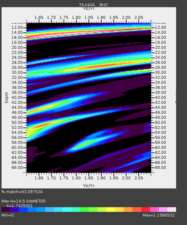
| Estimated Moho Depth: |
14.5 km |
| Estimated Crust Vp/Vs: |
1.74 |
| Assumed Crust Vp: |
6.53 km/s |
| Estimated Crust Vs: |
3.748 km/s |
| Estimated Crust Poisson's Ratio: |
0.25 |
|
| Radial Match: |
83.097534 % |
| Radial Bump: |
400 |
| Transverse Match: |
39.99604 % |
| Transverse Bump: |
398 |
| SOD ConfigId: |
439822 |
| Insert Time: |
2012-04-27 08:12:25.883 +0000 |
| GWidth: |
2.5 |
| Max Bumps: |
400 |
| Tol: |
0.001 |
|

Signal To Noise
| Channel | StoN | STA | LTA |
| TA:K40A: :BHZ:20120213T11:01:21.174985Z | 3.761724 | 1.3579477E-6 | 3.6099075E-7 |
| TA:K40A: :BHN:20120213T11:01:21.174985Z | 2.943931 | 8.1019283E-7 | 2.752078E-7 |
| TA:K40A: :BHE:20120213T11:01:21.174985Z | 1.8800579 | 4.5114544E-7 | 2.3996358E-7 |
| Arrivals |
| Ps | 1.8 SECOND |
| PpPs | 5.6 SECOND |
| PsPs/PpSs | 7.4 SECOND |


