You are here: Home > Network List > TA - USArray Transportable Network (new EarthScope stations) Stations List
> Station N45A Kentland, IN, USA > Earthquake Result Viewer
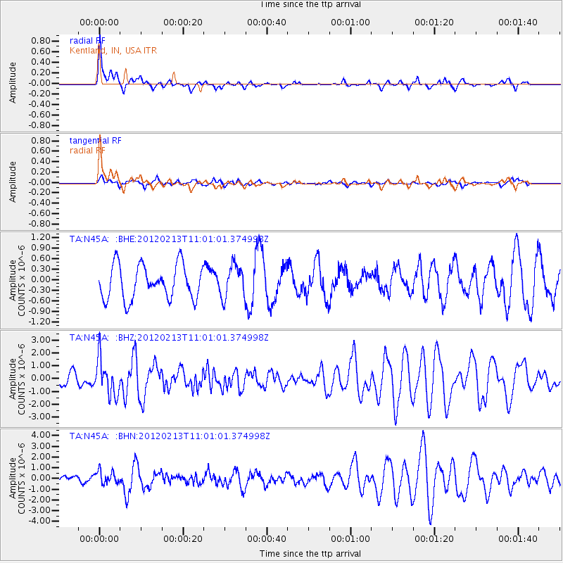
N45A Kentland, IN, USA - Earthquake Result Viewer
*The percent match for this event was below the threshold and hence no stack was calculated.
| Earthquake location: |
Costa Rica |
| Earthquake latitude/longitude: |
9.2/-84.1 |
| Earthquake time(UTC): |
2012/02/13 (044) 10:55:09 GMT |
| Earthquake Depth: |
16 km |
| Earthquake Magnitude: |
5.6 MB, 5.5 MS, 5.9 MW, 5.7 MW |
| Earthquake Catalog/Contributor: |
WHDF/NEIC |
|
| Network: |
TA USArray Transportable Network (new EarthScope stations) |
| Station: |
N45A Kentland, IN, USA |
| Lat/Lon: |
40.85 N/87.51 W |
| Elevation: |
206 m |
|
| Distance: |
31.7 deg |
| Az: |
355.099 deg |
| Baz: |
173.615 deg |
| Ray Param: |
$rayparam |
*The percent match for this event was below the threshold and hence was not used in the summary stack. |
|
| Radial Match: |
76.29787 % |
| Radial Bump: |
320 |
| Transverse Match: |
59.845497 % |
| Transverse Bump: |
400 |
| SOD ConfigId: |
439822 |
| Insert Time: |
2012-04-27 08:14:09.646 +0000 |
| GWidth: |
2.5 |
| Max Bumps: |
400 |
| Tol: |
0.001 |
|
Signal To Noise
| Channel | StoN | STA | LTA |
| TA:N45A: :BHZ:20120213T11:01:01.374998Z | 4.418495 | 1.449917E-6 | 3.2814725E-7 |
| TA:N45A: :BHN:20120213T11:01:01.374998Z | 1.058747 | 6.0961884E-7 | 5.757927E-7 |
| TA:N45A: :BHE:20120213T11:01:01.374998Z | 0.9848257 | 4.7329388E-7 | 4.805865E-7 |
| Arrivals |
| Ps | |
| PpPs | |
| PsPs/PpSs | |


