You are here: Home > Network List > G - GEOSCOPE Stations List
> Station INU Inuyama, Japan > Earthquake Result Viewer
INU Inuyama, Japan - Earthquake Result Viewer
| Earthquake location: |
New Britain Region, P.N.G. |
| Earthquake latitude/longitude: |
-5.1/151.0 |
| Earthquake time(UTC): |
1990/12/30 (364) 19:14:19 GMT |
| Earthquake Depth: |
188 km |
| Earthquake Magnitude: |
6.7 MB, 7.0 MS |
| Earthquake Catalog/Contributor: |
WHDF/NEIC |
|
| Network: |
G GEOSCOPE |
| Station: |
INU Inuyama, Japan |
| Lat/Lon: |
35.35 N/137.03 E |
| Elevation: |
132 m |
|
| Distance: |
42.3 deg |
| Az: |
342.971 deg |
| Baz: |
159.093 deg |
| Ray Param: |
0.07253163 |
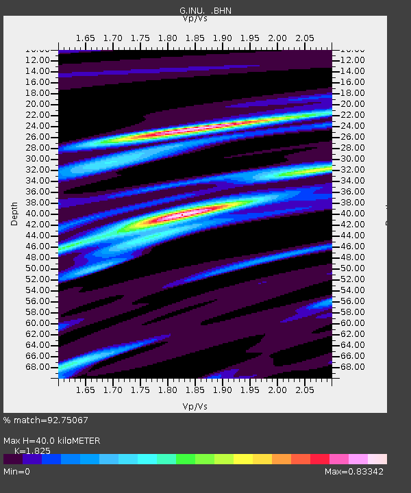
| Estimated Moho Depth: |
40.0 km |
| Estimated Crust Vp/Vs: |
1.83 |
| Assumed Crust Vp: |
6.461 km/s |
| Estimated Crust Vs: |
3.541 km/s |
| Estimated Crust Poisson's Ratio: |
0.29 |
|
| Radial Match: |
92.75067 % |
| Radial Bump: |
310 |
| Transverse Match: |
63.700012 % |
| Transverse Bump: |
400 |
| SOD ConfigId: |
16938 |
| Insert Time: |
2010-02-26 23:11:15.653 +0000 |
| GWidth: |
2.5 |
| Max Bumps: |
400 |
| Tol: |
0.001 |
|
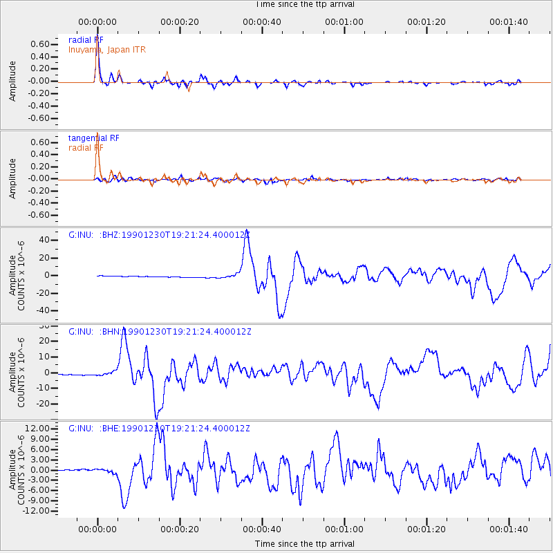
Signal To Noise
| Channel | StoN | STA | LTA |
| G:INU: :BHN:19901230T19:21:24.400012Z | 3.222157 | 1.3339655E-6 | 4.1399767E-7 |
| G:INU: :BHE:19901230T19:21:24.400012Z | 3.0652142 | 5.991335E-7 | 1.9546219E-7 |
| G:INU: :BHZ:19901230T19:21:24.400012Z | 4.4032936 | 2.7216E-6 | 6.1808277E-7 |
| Arrivals |
| Ps | 5.5 SECOND |
| PpPs | 16 SECOND |
| PsPs/PpSs | 22 SECOND |


